Filter: Categories of Wisconsin Historical Images
Filter: COLLECTION_NAME of Place File*
Filter: Year of 1900-1999
Filter: Year of 1940-1949
Filter: Creator Name of Unknown
Filter: Categories of Wisconsin Historical Images
Filter: COLLECTION_NAME of Place File*
Filter: Year of 1900-1999
Filter: Year of 1940-1949
Filter: Creator Name of Unknown
| Date: | 1940 |
|---|---|
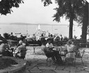
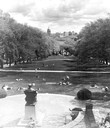
| Description: | Summertime view of people at tables on University of Wisconsin-Madison Memorial Union terrace, looking out to canoes and sailboats on the lake. In the back... |

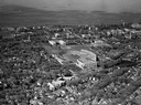
| Date: | 1940 |
|---|---|
| Description: | Aerial view looking east over the center of the city and the University of Wisconsin-Madison campus. |
| Date: | 1948 |
|---|---|
| Description: | A view down Park Street at Olin Avenue. On the corner of Olin is Moore's Super Service Mobil Station and McCranner Drugs. |
| Date: | 1940 |
|---|---|
| Description: | Exterior of north walkway of Bascom Hall (formerly Main Hall) on the University of Wisconsin-Madison campus. The Lincoln Monument is on the left, and a car... |
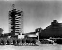
| Date: | 1949 |
|---|---|
| Description: | View of the Johnson Wax Research and Development Tower under construction. |
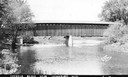
| Date: | 1940 |
|---|---|
| Description: | Exterior view of the last covered bridge in Wisconsin. Caption reads: "Covered Bridge Near Cedarburg, Wis." |
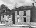
| Date: | 1945 |
|---|---|
| Description: | Pendarvis and Trelawny, Cornish miners' houses on Shake Rag Street. |
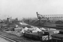
| Date: | 1940 |
|---|---|
| Description: | An industrial area of Milwaukee known as Menominee Valley. |
| Date: | 1948 |
|---|---|
| Description: | Wisconsin State Capitol from the south side of Monona Bay. |
| Date: | 1948 |
|---|---|
| Description: | Elevated view of University of Wisconsin-Madison's upper campus from Lincoln Terrace down Bascom Hill. The Wisconsin State Capitol can be seen in the dista... |
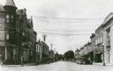
| Date: | 1940 |
|---|---|
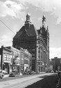
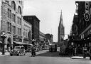
| Description: | View of a variety of storefronts in bustling downtown. On the left side of the street is Berman's, Cremer's Jewelers, Liggett's Drugs, and Kinney's Shoes. ... |
| Date: | 1945 |
|---|---|
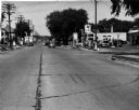
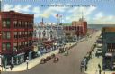
| Description: | View of Tower Avenue, looking north. A drugstore is on the corner (right), as well as an auto parts store. |
| Date: | 1944 |
|---|---|
| Description: | View of storefronts on Main Street, including a drugstore with soda fountain on the left. |
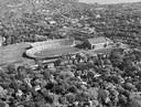
| Date: | 1948 |
|---|---|
| Description: | Aerial view of Camp Randall Stadium and Field House. |

| Date: | 1945 |
|---|---|
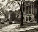
| Description: | View of the lower campus of the University of Wisconsin-Madison includes Bascom Hill, Wisconsin Historical Society, Memorial Union and the Armory (Red Gym ... |

| Date: | 1945 |
|---|---|
| Description: | Aerial view of Bascom Hill, Bascom Hall, Wisconsin Historical Society on the University of Wisconsin Madison campus with Lake Mendota on the right. |
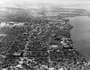
| Date: | 1946 |
|---|---|
| Description: | Aerial view of the University of Wisconsin campus with Lake Mendota on the right. |
| Date: | 1948 |
|---|---|
| Description: | Aerial view of Camp Randall Stadium and Field House looking north on the University of Wisconsin-Madison campus with Lake Mendota in the background. |
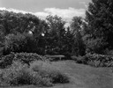
| Date: | 1940 |
|---|---|
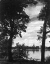
| Description: | View of Babcock Memorial Garden on the University of Wisconsin campus with bench. |
If you didn't find the material you searched for, our Library Reference Staff can help.
Call our reference desk at 608-264-6535 or email us at: