Filter: Categories of Wisconsin Historical Images
Filter: COLLECTION_NAME of Place File*
Filter: Subject of transportation
Filter: Categories of Wisconsin Historical Images
Filter: COLLECTION_NAME of Place File*
Filter: Subject of transportation
| Date: | |
|---|---|
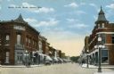
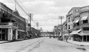
| Description: | View of businesses on South Water Street, including the Monroe County Bank and a drugstore on the left. Caption reads: "South Water Street, Sparta, Wis." |
| Date: | 1909 |
|---|---|
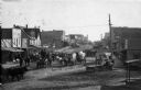
| Description: | View of horse-drawn traffic in downtown Shattuck. Businesses on the left side of the street include the "White House," a saloon, and the Davis Drug company... |
| Date: | 1930 |
|---|---|
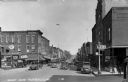
| Description: | View looking east down Main Street at the intersection with Court Street. Coyle's Drugstore is on the right. |
| Date: | 1915 |
|---|---|
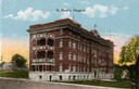
| Description: | St. Mary's Hospital soon after its completion in 1911. Caption reads: "St. Mary's Hospital." |
| Date: | 1915 |
|---|---|
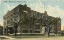
| Description: | Central High School, designed by St. Paul architect Cass Gilbert and partially razed in 1986. Caption reads: "High School, Madison, Wis." |
| Date: | 1915 |
|---|---|
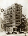
| Description: | Exterior view of the neoclassical Gay Building, named after Madison developer Leonard W. Gay, at 16 N Carroll Street, one of the first high-rise buildings ... |
| Date: | 1910 |
|---|---|
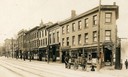
| Description: | View across street towards the north side of the 200 block of State Street between Fairchild and Henry Streets. This side was free of saloons. The south si... |

| Date: | 1879 |
|---|---|
| Description: | Bird's-eye view of Wisconsin State University, now the University of Wisconsin-Madison. Vignettes include Ladies Hall, South Dormitory, University Hall, As... |
| Date: | 1853 |
|---|---|
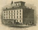
| Description: | Illustration of the Capital house, a first-class hotel, copied from page 320 of Gleason's Pictorial Drawing-Room Companion. |
| Date: | 1848 |
|---|---|
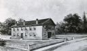
| Description: | Sketch of the Madison Women's Seminary on the corner of Wisconsin Avenue and East Johnson. The Madison Female Academy was a 19th century school for girls w... |
| Date: | 1910 |
|---|---|
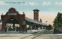
| Description: | Colorized view of the Chicago & Northwestern Railway Depot at Beloit. Caption reads: "C. & N. W. Depot, Beloit, Wis." |
| Date: | 1910 |
|---|---|
| Description: | View down East Grand Avenue of the business district with a shoe business at the end of the street and the Hilton Hotel to the left. |

| Date: | 1861 |
|---|---|
| Description: | Bird's-eye map of Fond du Lac, "drawn after nature," with a parade of soldiers marching down the street. |

| Date: | 1875 |
|---|---|
| Description: | Bird's-eye map after a fire destroyed a large area of the town. In memory of the Great Conflagration on April 28th, 1875. Taken from the North-Side. |

| Date: | 1893 |
|---|---|
| Description: | Bird's-eye map of Sturgeon Bay, looking Northeast. Area bordered by Church Street in top left corner, leather & Smith Bridge in bottom left corner, Lawrenc... |

| Date: | 1880 |
|---|---|
| Description: | Bird's-eye map of Sturgeon Bay. County Seat of Door County. |
| Date: | 1920 |
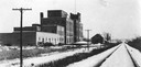
|---|---|
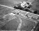
| Description: | Exterior view of the United States Sugar Company factory next to railroad tracks on Atwood Avenue. The building was occupied in 1980 by Garver Feed & Suppl... |
If you didn't find the material you searched for, our Library Reference Staff can help.
Call our reference desk at 608-264-6535 or email us at: