Filter: Categories of Wisconsin Historical Images
Filter: COLLECTION_NAME of Place File*
Filter: Subject of architecture
Filter: Subject of trees
Filter: Creator Name of Newhouse, John
Filter: Categories of Wisconsin Historical Images
Filter: COLLECTION_NAME of Place File*
Filter: Subject of architecture
Filter: Subject of trees
Filter: Creator Name of Newhouse, John
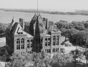
| Date: | 1958 |
|---|---|
| Description: | Elevated view of the Dane County Courthouse as it is being razed. Much of it is still intact in this image. Lake Monona and Monona Bay are in the distance. |

| Date: | 1956 |
|---|---|
| Description: | Aerial view of lower University of Wisconsin-Madison campus with demolition of buildings on both sides of the Armory-Gymnasium to make space for future pla... |

| Date: | 1956 |
|---|---|
| Description: | Aerial view of upper campus of the University of Wisconsin-Madison with Lake Mendota. |
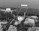
| Date: | 1958 |
|---|---|
| Description: | Aerial view of upper campus on the University of Wisconsin-Madison. Typewritten labels mark the location of Elizabeth Waters Hall, New Commerce Building, L... |

| Date: | 1956 |
|---|---|
| Description: | Aerial view looking east along Madison's Lake Mendota shoreline. The large building under construction at center is Carroll Hall, a University of Wisconsin... |
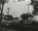
| Date: | 1955 |
|---|---|
| Description: | The intersection of Johnson and Broom Streets. |
| Date: | 1945 |
|---|---|
| Description: | View of the Midway Barns, constructed in 1938 on the farmland adjoining Taliesin, Frank Lloyd Wright's residence and architectural school complex. Taliesin... |

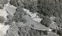
| Date: | 1945 |
|---|---|
| Description: | Aerial view of Taliesin, Frank Lloyd Wright's residence and architectural school complex, with the Wisconsin River visible at the top. Taliesin is located... |
| Date: | 1957 |
|---|---|
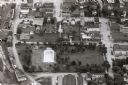
| Description: | Aerial view of downtown, including park, church, and stores. |
| Date: | 1957 |
|---|---|
| Description: | Aerial view of Campion College of the Sacred Heart. |

| Date: | 1957 |
|---|---|
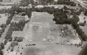
| Description: | Aerial view of town including water tower, city streets, houses, and other buildings. |
| Date: | 1957 |
|---|---|
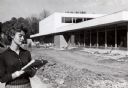
| Description: | Wisconsin State College (later renamed the University of Wisconsin-Platteville). The Student Union is in final stages of construction, and in the foregroun... |
| Date: | 1954 |
|---|---|
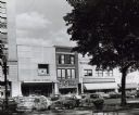
| Description: | Pinckney Street, near the corner of East Washington Avenue. To the left is a bank building, in the center a shoe store, and on the right a theatre. |
| Date: | 1956 |
|---|---|
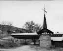
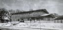
| Description: | A wintery view of the rectory of the Queen of Peace church lacated at 418 Holly Avenue. |

| Date: | 1954 |
|---|---|
| Description: | View from intersection towards the Wisconsin Building, which was built in 1901. Located at the intersection of State and Carroll Streets, at 102 State Stre... |

| Date: | 09 1954 |
|---|---|
| Description: | Elevated view of Wisconsin Avenue from the Wisconsin State Capitol balcony. At the lower left, the demolition of old City Hall is in progress, which began ... |

| Date: | 1956 |
|---|---|
| Description: | Aerial view over University Avenue of the University of Wisconsin-Madison campus, including University farm in the upper middle. The shoreline of Lake Mend... |
If you didn't find the material you searched for, our Library Reference Staff can help.
Call our reference desk at 608-264-6535 or email us at: