 Filter: Categories of Wisconsin Historical Images
Filter: COLLECTION_NAME of Map Collection
Filter: Year of 1900-1999
Filter: Year of 1990-1999
Filter: Categories of Wisconsin Historical Images
Filter: COLLECTION_NAME of Map Collection
Filter: Year of 1900-1999
Filter: Year of 1990-1999

| Date: | 1994 |
|---|---|
| Description: | This brochure consists of a series of 16 maps of the Elroy-Sparta State Trail and the 400 State Trail, as well as the Omaha Trail between Sparta and Camp D... |

| Date: | 1994 |
|---|---|
| Description: | This brochure presents a series of 16 maps of the Glacial Drumlin Trail and the New Berlin Trail. The Glacial Drumlin Trail consists of 53 miles of bike tr... |

| Date: | 1994 |
|---|---|
| Description: | This brochure consists of a series of 16 maps of the Military Ridge State Park Trail and the Sugar River State Trail. In all, 62 miles of bike trails and 1... |

| Date: | 1991 |
|---|---|
| Description: | This canoe guide depicts the Wisconsin River from just north of Prairie du Sac to near Spring Green. Landmarks and points of interest are identified and de... |

| Date: | 1990 |
|---|---|
| Description: | A tourist map of Lafayette County, Wisconsin, that shows the locations of motels, camping, municipal parks, cheese factory tours, waysides, and golf course... |

| Date: | 1993 |
|---|---|
| Description: | A series of three maps showing the lands of the Menominee, the first of these three maps shows the present-day Menominee Indian Reservation. Highways and r... |

| Date: | 1993 |
|---|---|
| Description: | A map of Milwaukee County, indicating the locations of toxic sites and the types of toxic sites, ranging from those listed as a superfund site, industry re... |

| Date: | 1990 |
|---|---|
| Description: | This late 20th century tourist map of Sauk County, Wisconsin, shows the highways and roads, cities and towns, parks, airports, canoe landings, hospitals, s... |
| Date: | 1991 |
|---|---|
| Description: | A map of Shawano Lake. Lake depths are shown by isolines. "Not intended for navigation." It includes a location map and a list of fish. |

| Date: | 1990 |
|---|---|
| Description: | This tourism brochure of Ashland County, Wisconsin, from the Ashland Area Chamber of Commerce includes a map of the county showing tourist destinations and... |

| Date: | 1991 |
|---|---|
| Description: | This 1991 map of Burnett County, Wisconsin, shows Governor Knowles State Forest, wildlife areas, public hunting grounds, and other outdoor recreation facil... |
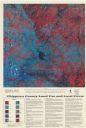
| Date: | 1993 |
|---|---|
| Description: | This satellite image of Chippewa County, Wisconsin, documents the land use and land cover of the county as recorded June 11, 1992. Accompanying text descri... |

| Date: | 1992 |
|---|---|
| Description: | This 1992 map of Wood County, Wisconsin, shows towns, sections, cities and villages, highways and roads, railroads, and lakes and streams. An inset map of ... |

| Date: | 1990 |
|---|---|
| Description: | Map of bike routes in Madison. Lower right corner features a system map with legend. Upper left corner is an inset of the Capital Loop with labelled points... |

| Date: | 1995 |
|---|---|
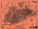
| Description: | This map of La Crosse is a bird’s-eye-view map with relief shown pictorially. The cover lists many points of interests and activities in La Crosse. The cov... |

| Date: | 1992 |
|---|---|
| Description: | This guide features a map of suggested bike routes. Also included is a legend, text on how to use the map and legend, points of interest, safety tips, and ... |

| Date: | 1992 |
|---|---|
| Description: | This guide features a map of suggested bike routes. Also included is a legend, text on how to use the map and legend, points of interest, and safety tips. |
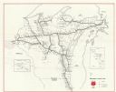
| Date: | 1990 |
|---|---|
| Description: | This map shows main railroad track, lines out of service, abandoned lines, and trackage rights. The back of the map shows Wisconsin Central Ltd. lines and ... |

| Date: | 1996 |
|---|---|
| Description: | This map shows roads, lakes, points of interest including colleges, trails, historic communities and sites, museums, and parks. Also included are descripti... |

| Date: | 1994 |
|---|---|
| Description: | This map is divided and color coded by forest type. Portions of Michigan, Minnesota, Lake Michigan and Lake Superior are labeled. The reverse includes a sm... |
If you didn't find the material you searched for, our Library Reference Staff can help.
Call our reference desk at 608-264-6535 or email us at: