 Filter: Categories of Wisconsin Historical Images
Filter: COLLECTION_NAME of Map Collection
Filter: Year of 1900-1999
Filter: Year of 1980-1989
Filter: Categories of Wisconsin Historical Images
Filter: COLLECTION_NAME of Map Collection
Filter: Year of 1900-1999
Filter: Year of 1980-1989

| Date: | 1981 |
|---|---|
| Description: | Plat map of Madeline Island surrounded by Basswood, Michigan and Gull Islands. |
| Date: | 1980 |
|---|---|
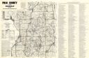
| Description: | This road map of Polk County, Wisconsin, has been annotated to show the location of historic sites in the county and is accompanied by a 1980 directory of ... |

| Date: | 1987 |
|---|---|
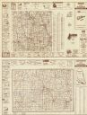
| Description: | This 1987 map of Door County, Wisconsin, shows streets and roads, cities and villages, state parks, lakes and streams, and depths in Lake Michigan. A stree... |

| Date: | 1986 |
|---|---|
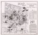
| Description: | This late 1980s map of Price County, Wisconsin, shows facilities and lands open for public recreation, hunter walking trails and ski trails, campgrounds, b... |

| Date: | 1987 |
|---|---|
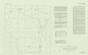
| Description: | This 1987 map of Racine and Kenosha counties, Wisconsin, shows towns, sections, cities and villages, zip code boundaries, highways and roads, bicycle route... |
| Date: | 1984 |
|---|---|
| Description: | On verso: Map of Lafayette County, Wisconsin. Panel title. Shows roads, railroads, and highways. Includes indexes. Also includes advertisements and illustr... |

| Date: | 1987 |
|---|---|
| Description: | This map pictorially shows local roads, local businesses with phone numbers, and parts of Fox River and bay of Green Bay. |

| Date: | 1982 |
|---|---|
| Description: | Color map. "Topography by photogrammetric methods from aerial photographs taken 1963. Revised from aerial photographs taken 1978. Field checked 1979. Map e... |

| Date: | 1987 |
|---|---|
| Description: | This pictorial map shows roads, bridges, local businesses with phone numbers, and public buildings. Relief is shown pictorially. Also included is a calen... |

| Date: | 1989 |
|---|---|
| Description: | This pictorial map shows the Sheboygan river, businesses with phone numbers, historical buildings, other places of interest, and includes a brief history o... |

| Date: | 1986 |
|---|---|
| Description: | Pictorial map showing businesses with phone numbers, roads, railroads, and parks. Includes text titled: "History of Portage County." |

| Date: | 1989 |
|---|---|
| Description: | This pictorial map shows Lake Michigan, businesses with phone numbers, schools, parks, other points of interest, and includes a brief history of the town. ... |
| Date: | 1987 |
|---|---|
| Description: | This map shows reservoirs, drainage areas, and parts of of Lincoln, Langlade, Forest, Oneida, and Vilas counties. Includes 1 inset map of corrections for R... |
| Date: | 1980 |
|---|---|
| Description: | This map shows earthquake data and includes text about tables, references, and the Modified Mercalli Intensity Scale of 1931. Table one lists earthquakes c... |
| Date: | 1987 |
|---|---|
| Description: | This map shows creeks, lakes, ponds, and rivers. Also included are illustrations and a table of trout food, tips on trout fishing and notes on top trout st... |

| Date: | 1980 |
|---|---|
| Description: | This map shows schools, hotels, stations, roads, railroads, reefs, and public buildings. The upper right corner includes "A Summer and Winter Guide for Spo... |

| Date: | 1989 |
|---|---|
| Description: | This color coded map shows the various rivers, lakes, bays, and islands that make up the harbor. It includes an index of industries (maritime and non-marit... |

| Date: | 1980 |
|---|---|
| Description: | This map shows the locations of 42 businesses, roads, points of interest, recreation sites, camping, the North Country Trail and parking, and boundaries of... |

| Date: | 1985 |
|---|---|
| Description: | This map shows mining, White River, Silver Creek, Bad River, Agogic Lake, Chequamegon Bay, smaller lakes, the Bad River Indian Reservation, and communities... |

| Date: | 1987 |
|---|---|
| Description: | This map shows federal highways, state or county highways, rivers, lakes, town roads, township boundaries, county boundaries, national or state forest, loo... |
If you didn't find the material you searched for, our Library Reference Staff can help.
Call our reference desk at 608-264-6535 or email us at: