 Filter: Categories of Wisconsin Historical Images
Filter: COLLECTION_NAME of Map Collection
Filter: Year of 1900-1999
Filter: Categories of Wisconsin Historical Images
Filter: COLLECTION_NAME of Map Collection
Filter: Year of 1900-1999
| Date: | 1924 |
|---|---|
| Description: | Map of Verona in Dane County from the Charles Brown Atlas. |

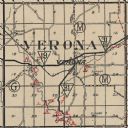
| Date: | 1920 |
|---|---|
| Description: | Detail of a map of Dane county showing only Verona. |

| Date: | 1913 |
|---|---|
| Description: | A wall atlas of Sauk County, Wisconsin, displaying its 22 towns. On the left side are advertisements for local businesses. |
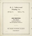
| Date: | 1931 |
|---|---|
| Description: | An advertisement for H.C. Netherwood Printing Company (formerly) at 519 State Street in Madison, Wisconsin. |
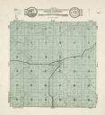
| Date: | 1931 |
|---|---|
| Description: | A map of the township of Verona, Wisconsin. |

| Date: | 1931 |
|---|---|
| Description: | A map of the village of Verona, Wisconsin. |

| Date: | 1930 |
|---|---|
| Description: | Pictorial map of Glacier National Park, Montana and Waterton Lakes National Park, Alberta. Illustrated by Joe Scheurle, it depicts white people, American ... |

| Date: | 1930 |
|---|---|
| Description: | The back of the pictorial map titled Recreational Map of Glacier National Park, Montana: Waterton Lakes National Park, Alberta. 14 panels of text and photo... |

| Date: | 1918 |
|---|---|
| Description: | A map of primarily of Wisconsin, but also includes the areas of northern Illinois, eastern portions of Minnesota and Iowa, and Michigan’s Upper Peninsula, ... |

| Date: | 1952 |
|---|---|
| Description: | The famous Dells of the Wisconsin River. A souvenir map embellished with bits of history and points of interest. |

| Date: | 1909 |
|---|---|
| Description: | Map of Sawyer County with an advertisement for land sales through Fuley & Quail of Hayward, Wisconsin. There is a small inset map of railroads accessible i... |

| Date: | 1914 |
|---|---|
| Description: | North part of Waukesha County. From Atlas of Waukesha County. Pages 10 - 11. |

| Date: | 1981 |
|---|---|
| Description: | Plat map of Madeline Island surrounded by Basswood, Michigan and Gull Islands. |

| Date: | 1968 |
|---|---|
| Description: | This map shows lakes, rivers and soil types. Lake Michigan, Lake Superior, and portions of Illinois, Iowa, Michigan, and Minnesota are labeled. A legend to... |

| Date: | 1912 |
|---|---|
| Description: | This map shows parcel zones, counties, electric lines, and railroads. Includes text and charts about parcel post regulations and laws. Also includes an ins... |
If you didn't find the material you searched for, our Library Reference Staff can help.
Call our reference desk at 608-264-6535 or email us at:


