 Filter: Categories of Wisconsin Historical Images
Filter: COLLECTION_NAME of Map Collection
Filter: Year of 1800-1899
Filter: Year of 1890-1899
Filter: Categories of Wisconsin Historical Images
Filter: COLLECTION_NAME of Map Collection
Filter: Year of 1800-1899
Filter: Year of 1890-1899

| Date: | 1899 |
|---|---|
| Description: | This map shows parks, block numbers, Lake Michigan, and railroads. Relief is shown by contours. Also included is an explanation that lists how many miles o... |

| Date: | 1899 |
|---|---|
| Description: | A plat map showing Lake Monona, the isthmus in Madison, and the towns of Burke and Blooming Grove. |

| Date: | 1896 |
|---|---|
| Description: | This map shows plat of town, local streets, numbered blocks and lots, mill pond, mills, part of the Red Cedar River, and land and property ownership by nam... |

| Date: | 1894 |
|---|---|
| Description: | This map shows sewers, intercepting sewers, manholes, block numbers, streets, railroads, parks, cemeteries, and Lake Michigan. The right margin reads: "Tot... |

| Date: | 1896 |
|---|---|
| Description: | This map shows streets, wards, railroads, parks, cemeteries, and Lake Michigan. Also included are explanations and an index of points of interest. |

| Date: | 1897 |
|---|---|
| Description: | Two maps that show cemeteries, schools, engine houses, railroads, street railways, wards, roads, parks, block numbers, and Lake Michigan. One map has wards... |

| Date: | 1890 |
|---|---|
| Description: | This map shows city wards, block numbers, parks, cemeteries, roads, railroads, and selected buildings. The map includes indexes to streets, public building... |

| Date: | 1891 |
|---|---|
| Description: | This map shows vacant Southwick & Sellers lands, settlers' houses, Goodland Co. land, schools, churches, saw mills, roads, and railroads. A key in the uppe... |

| Date: | 1895 |
|---|---|
| Description: | Map showing the continents of the world with the Americas at the center. From left to right land masses names are: "Siberia, Chinese Empire, Australia, Nor... |

| Date: | 1893 |
|---|---|
| Description: | This map shows the depths of the East Neebish Rapids and the different types of minerals that make up the floor bed. Islands and Canada West is labeled. No... |

| Date: | 1890 |
|---|---|
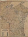
| Description: | This map shows railroad routes, rivers, and lakes throughout the north central states, primarily North and South Dakota, Minnesota, Wisconsin, Illinois, Io... |

| Date: | 1896 |
|---|---|
| Description: | This map shows railroad routes in red, blue, orange, brown, pink, green, and dotted, as well as lakes, rivers, and communities. The map includes a legend i... |
| Date: | 1898 |
|---|---|
| Description: | This map shows railroad routes in red, blue, orange, brown, pink, green, and dotted, as well as lakes, rivers, and communities. The map includes a legend i... |

| Date: | 1891 |
|---|---|
| Description: | This blueprint manuscript map shows land owned by Green Bay & Mississippi Canal Co., Meade, Vilas, Patten, and Hewitt. Streets and the Fox River are labele... |

| Date: | 1891 |
|---|---|
| Description: | This blueprint manuscript map shows land owned by Kaukauna Water Power Co., Green Bay & Mississippi Canal Co., A.W. Patten, N.M. Edwards, and M.J. Meade. P... |

| Date: | 10 1891 |
|---|---|
| Description: | This blueprint map shows land ownership and buildings. Text below the title reads: "The La Crosse Heights include the ridge of land with the spurs projecti... |

| Date: | 1899 |
|---|---|
| Description: | A map of the west part of the city of Madison, including University Heights and the Capitol Square. |

| Date: | 1899 |
|---|---|
| Description: | A map of the east part of the city of Madison, including a portion of the isthmus. |

| Date: | 1890 |
|---|---|
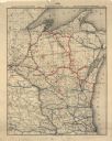
| Description: | This map shows the congressional districts lines in accordance with the 1890 census. Districts are labeled by number and color. Original caption reads, "Sh... |
| Date: | 1892 |
|---|---|
| Description: | This map shows railroad routes. County boundaries, towns, rivers, lakes, Lake Michigan and Superior are also labeled. The upper margin includes a color leg... |
If you didn't find the material you searched for, our Library Reference Staff can help.
Call our reference desk at 608-264-6535 or email us at: