 Filter: Categories of Wisconsin Historical Images
Filter: COLLECTION_NAME of Map Collection
Filter: Year of 1800-1899
Filter: Year of 1830-1839
Filter: Categories of Wisconsin Historical Images
Filter: COLLECTION_NAME of Map Collection
Filter: Year of 1800-1899
Filter: Year of 1830-1839

| Date: | 07 02 1836 |
|---|---|
| Description: | An ink on paper, hand-drawn map shows the sections and streams in Township 5, Range 1 east, which covers parts of the present-day towns of Mifflin and Lind... |

| Date: | 1836 |
|---|---|
| Description: | An ink on paper, hand-drawn map of the survey of the (Township No. 8, Range No. 16 East of the 4 Meridian) Town of Ixonia, Jefferson County, Wisconsin incl... |

| Date: | 1836 |
|---|---|
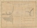
| Description: | A detailed map of the mouth of the Kewaunee River, showing the geological composition of the Lake Michigan shoreline and the various water depths in the ar... |

| Date: | 1836 |
|---|---|
| Description: | A series of ink, watercolor, and pencil on paper, hand-drawn maps of the townships of Darlington and Gratiot in Lafayette County, Wisconsin, showing the to... |
| Date: | 1836 |
|---|---|
| Description: | A hand-drawn map of the mouth of the Manitowoc River at Lake Michigan, showing depth of the water by contour lines. The included inset map shows the region... |

| Date: | 1830 |
|---|---|
| Description: | A hand-drawn map of the township sectioning of Milwaukee, eastern Waukesha, northern Walworth, and Racine Counties. Other items shown in the map are the la... |

| Date: | 1837 |
|---|---|
| Description: | A pen and ink on tracing paper, hand-drawn and colored map the proposed route of the Milwaukee and Rock River Canal, ranging from the Rock River in the wes... |

| Date: | 1838 |
|---|---|
| Description: | A map of the proposed route of the Milwaukee and Rock River Canal from Fort Atkinson on the Rock River in the west to the city of Milwaukee and Lake Michig... |

| Date: | 1830 |
|---|---|
| Description: | An ink on paper, hand-drawn map of the town of Milwaukee, showing the divisions and landownership within the town by private individuals as well as those l... |

| Date: | 1836 |
|---|---|
| Description: | This early to mid-19th century map shows the township and range system, sections, landownership, furnaces, lead mines, copper mines, and roads in the vicin... |

| Date: | 1830 |
|---|---|
| Description: | This early 19th century manuscript map of Prairie du Chien, Wisconsin, shows sections, landownership and acreages, roads, and ferries in the towns of Bridg... |

| Date: | 1836 |
|---|---|
| Description: | This 1836 map consists chiefly of a detailed map of the the mouth of the Sheboygan River. An inset map of the region and cross section diagrams of the pier... |

| Date: | 1834 |
|---|---|
| Description: | This copy of an 1834 map in the American Fur Company's papers held by the New-York Historical Society shows an outline of Chequamegon Bay and Madeline Isla... |

| Date: | 10 19 1836 |
|---|---|
| Description: | This 1836 manuscript map shows the sections, windfalls, marshes, streams, prairies, acreages, and former mouth of the Pike River in what is now the eastern... |

| Date: | 1836 |
|---|---|
| Description: | This manuscript shows the 1835 survey of the road corresponding approximately to a portion of County Trunk A in the Town of Scott, Brown County, Wisconsin.... |

| Date: | 1837 |
|---|---|
| Description: | This manuscript map, copied in 1837 from a map in the Green Bay Land Office, Navarino, shows sections, the Shebowegan Trail, sandstone ledges, rivers, stre... |

| Date: | 1835 |
|---|---|
| Description: | This manuscript map of Dane County, Wisconsin, from the first half of the 19th century shows the township and range grid, sections, cities and villages bot... |

| Date: | 1835 |
|---|---|
| Description: | These maps of the towns of Westport, Madison, and Blooming Grove, Dane County, Wisconsin, show sections, roads, trails, lakes and streams, and wetlands fro... |

| Date: | 1836 |
|---|---|
| Description: | Map shows rivers, creeks, roads, trails, mills, and town of Madison. Includes significant manuscript annotations; Sheet 1 is watercolor on lithographed map... |

| Date: | 1835 |
|---|---|
| Description: | Shows Walker’s Point, Juneau Town and Kilbourn Town, including labeled buildings, trails and Indian villages. Relief shown by hachures. Oriented with north... |
If you didn't find the material you searched for, our Library Reference Staff can help.
Call our reference desk at 608-264-6535 or email us at: