 Filter: Categories of Wisconsin Historical Images
Filter: COLLECTION_NAME of Map Collection
Filter: Year of 1800-1899
Filter: Subject of water
Filter: Categories of Wisconsin Historical Images
Filter: COLLECTION_NAME of Map Collection
Filter: Year of 1800-1899
Filter: Subject of water

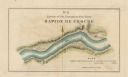
| Date: | 1840 |
|---|---|
| Description: | This map surveyed under the direction of Captain Thomas J. Cram is one in a series of seventeen that accompanied Cram's report on the Fox-Wisconsin river s... |

| Date: | 1840 |
|---|---|
| Description: | This map surveyed under the direction of Captain Thomas J. Cram is one in a series of seventeen that accompanied Cram's report on the Fox-Wisconsin river s... |
| Date: | 1840 |
|---|---|
| Description: | This map surveyed under the direction of Captain Thomas J. Cram is one in a series of seventeen that accompanied Cram's report on the Fox-Wisconsin river s... |
| Date: | 1840 |
|---|---|
| Description: | This map surveyed under the direction of Captain Thomas J. Cram is one in a series of seventeen that accompanied Cram's report on the Fox-Wisconsin river s... |

| Date: | 1840 |
|---|---|
| Description: | This map surveyed under the direction of Captain Thomas J. Cram is one in a series of seventeen that accompanied Cram's report on the Fox-Wisconsin river s... |

| Date: | 1840 |
|---|---|
| Description: | This map surveyed under the direction of Captain Thomas J. Cram is one in a series of seventeen that accompanied Cram's report on the Fox-Wisconsin river s... |

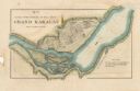
| Date: | 1840 |
|---|---|
| Description: | This map, one of a series made by Thomas Jefferson Cram of the U.S. Topographical Engineers from personal surveys, shows the portage connecting the Wiskons... |

| Date: | 1896 |
|---|---|
| Description: | Map showing the Wisconsin Central Railroad and its land grant, with the railroad and the land grant in color (red). |

| Date: | 1876 |
|---|---|
| Description: | Made from U.S. Surveys and from minutes furnished by Jos. S. Buck and Dr. C. Chase. Scale 20 CHs to an inch. |

| Date: | 1882 |
|---|---|
| Description: | This basic reference map of the state shows natural features, railroads, county seats, and political boundaries against the G.L.O. township and range grid.... |

| Date: | 1830 |
|---|---|
| Description: | A color map of the Michigan and Wisconsin territories with an inset showing the Ste. Marie River. |

| Date: | 1868 |
|---|---|
| Description: | Showing the counties, towns and railroads. Partly colored. Scale: 1 inch = 20 miles. |

| Date: | 1898 |
|---|---|
| Description: | Shows railway lines in Wisconsin marked in red and counties in colors. The meridians are Greenwich, Wisconsin and Washington, Wisconsin. The map folds into... |

| Date: | 1859 |
|---|---|
| Description: | This 1859 railroad map shows counties, cities, rivers and lakes in the entire state of Wisconsin. It includes an inset depicting the railroads in Milwaukee... |

| Date: | 1813 |
|---|---|
| Description: | Eastern half of the United States. Scale: 2.5 inches = 250 miles. |

| Date: | 1862 |
|---|---|
| Description: | Lithography of C. Van Benthuysen. |

| Date: | 1850 |
|---|---|
| Description: | [... through northern United States from New York to Minnesota]. Lithography by T. Sinclair. From Perrault papers, Lucien S. Hanks, donor. |

| Date: | 1839 |
|---|---|
| Description: | Shows locations of cities, towns, villages, post hamlets, canals, rail and stage roads. Includes table of steamboat routes and distances; vignette of "Maid... |

| Date: | 1853 |
|---|---|
| Description: | Shows railroads, planned and in place. |

| Date: | 1887 |
|---|---|
| Description: | Benedict & Co. engineers. As shown by development to March 1st 1887. Inset: Map of northern Wisconsin showing location of range. Lands in red. |
If you didn't find the material you searched for, our Library Reference Staff can help.
Call our reference desk at 608-264-6535 or email us at: