 Filter: Categories of Wisconsin Historical Images
Filter: COLLECTION_NAME of Map Collection
Filter: Subject of playgrounds
Filter: Categories of Wisconsin Historical Images
Filter: COLLECTION_NAME of Map Collection
Filter: Subject of playgrounds
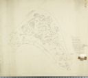
| Date: | 04 1945 |
|---|---|
| Description: | Graphite pencil and colored pencil drawing on drafting vellum of design for Glenwood Children's Park designed by Jens Jensen. Original drawing 33 x 29 inch... |

| Date: | 04 1945 |
|---|---|
| Description: | Topographic map of Park Lands in Glenwood Plat, Land for Glenwood Children's Park. Design by Jens Jensen. Oringinal drawing 35 x 34 inches. |

| Date: | 1931 |
|---|---|
| Description: | Map shows street map with wards numbered, the Fox River, railroads, playgrounds, cemeteries, and schools. The map also includes a manuscript annotation ind... |

| Date: | 1939 |
|---|---|
| Description: | This is a zoning map of Wauwatosa with a key of districts including agricultural, resident, business, commercial, and industrial. The map features labeled ... |

| Date: | 06 1931 |
|---|---|
| Description: | This map is a photocopy of a map that has been hand-colored and shows streets, the Wisconsin River, Mill Pond, and points of interest that include a school... |

| Date: | 1927 |
|---|---|
| Description: | This map shows street car lines, bus routes, railroads, proposed city boundary lines, wards, public schools, blocks & house numbers, Lake Michigan, one mil... |
If you didn't find the material you searched for, our Library Reference Staff can help.
Call our reference desk at 608-264-6535 or email us at: