 Filter: Categories of Wisconsin Historical Images
Filter: COLLECTION_NAME of Map Collection
Filter: Reproduction Rights of For Sale
Filter: Year of 1900-1999
Filter: Year of 1900-1909
Filter: Categories of Wisconsin Historical Images
Filter: COLLECTION_NAME of Map Collection
Filter: Reproduction Rights of For Sale
Filter: Year of 1900-1999
Filter: Year of 1900-1909

| Date: | 1908 |
|---|---|
| Description: | Colored map showing a panoramic view of Madison in great detail. The Wisconsin State Capitol is located at the center, with Lake Mendota in the background ... |

| Date: | 1907 |
|---|---|
| Description: | Bird's-eye view of the University of Wisconsin-Madison campus looking northwest. Building at top of hill, to left of center is Bascom Hill (Main Hall) and... |

| Date: | 1907 |
|---|---|
| Description: | Bird's-eye map of Chippewa Falls with insets of Chippewa Lumber & Boom Co., Opera House Block, Chippewa Falls Furniture Co., and J. Leinenkugel Brewing Co. |

| Date: | 1906 |
|---|---|
| Description: | Bird's-eye map of South Milwaukee. |

| Date: | 1905 |
|---|---|
| Description: | Map of state of Idaho. Department of Interior General Land Office. |

| Date: | 1904 |
|---|---|
| Description: | This map shows a plat of the east part of the city, numbered blocks and lots, some landownership, local streets, roads, railroads, wards by number, parks, ... |

| Date: | 1904 |
|---|---|
| Description: | This map shows a plat of the west part of the city, numbered blocks and lots, some landownership, local streets, roads, railroads, wards by number, parks, ... |

| Date: | 1909 |
|---|---|
| Description: | [Lithography] by Poole Bros. Contains descriptive information. Short jaunts for busy people to nearby resorts in Illinois and Wisconsin. |

| Date: | 1900 |
|---|---|
| Description: | Hydrographic map of Lake Mendota and it's adjacent topography. Prepared from surveys made by civil engineering students, University of Wisconsin, classes 1... |

| Date: | 1906 |
|---|---|
| Description: | Polyconic projection. Map made from surveys without spirit level control. Henry Gannett, Chief Topographer. Topography by Van H. Manning and Nat. Tyler, Jr... |

| Date: | 1908 |
|---|---|
| Description: | Colored map in perspective indicates railroad routes. Lake Winnebago and Oshkosh in center, area extends to Shawano (top right corner), Green Bay (bottom r... |

| Date: | 1907 |
|---|---|
| Description: | Topographic map of the Wisconsin River done under direction of Daniel Meade for construction of the Kilbourn dam by the Southern Wisconsin Power Company. I... |

| Date: | 1907 |
|---|---|
| Description: | Topographic map of the Wisconsin River done under direction of Daniel Meade for construction of the Kilbourn dam by the Southern Wisconsin Power Company. I... |

| Date: | 1900 |
|---|---|
| Description: | A hydrographic map of Lake Monona and the adjacent topography. |
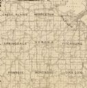
| Date: | 1904 |
|---|---|
| Description: | A map of Verona, which is a detail from a map of Dane County, Wisconsin. |

| Date: | 1909 |
|---|---|
| Description: | Map of Sawyer County with an advertisement for land sales through Fuley & Quail of Hayward, Wisconsin. There is a small inset map of railroads accessible i... |

| Date: | 1906 |
|---|---|
| Description: | Hand-drawn topographical map of the Turville Estate. |
If you didn't find the material you searched for, our Library Reference Staff can help.
Call our reference desk at 608-264-6535 or email us at:


