Filter: Categories of Wisconsin Historical Images
Filter: COLLECTION_NAME of Map Collection
Filter: Reproduction Rights of For Sale
Filter: Subject of land
Filter: Categories of Wisconsin Historical Images
Filter: COLLECTION_NAME of Map Collection
Filter: Reproduction Rights of For Sale
Filter: Subject of land

| Date: | 1828 |
|---|---|
| Description: | Plat of the Private Claims at Prairie Du Chien. |

| Date: | 1837 |
|---|---|
| Description: | Map of the proposed route of the Milwaukee and Rock River Canal. |
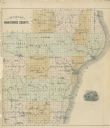
| Date: | 1878 |
|---|---|
| Description: | Outline map of Manitowoc County. Includes engraving of Wisconsin State Seal at bottom right. |

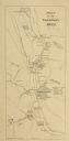
| Date: | 1890 |
|---|---|
| Description: | This map shows lakes, railroads, and rivers. An explanation of railroad lines with mileage in Wisconsin and total mileage for 1890 is included. Portions of... |
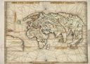
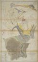
| Date: | 1513 |
|---|---|
| Description: | This exquisite woodcut map is one of the first to show any part of North America. It originally appeared in the 1513 Strasbourg edition of Ptolemy's Geogra... |

| Date: | 09 1854 |
|---|---|
| Description: | A map of government roads in Minnesota. |

| Date: | 1926 |
|---|---|
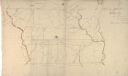
| Description: | This hand-colored blueprint map shows landowners in part of T15N, R5E in Juneau County. North is oriented to the right. |

| Date: | 1915 |
|---|---|
| Description: | Plat map of Polk township in Washington County. |
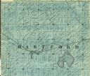
| Date: | 1859 |
|---|---|
| Description: | Detail of section 5 of the Washington County map showing only Hartford. |
| Date: | 1851 |
|---|---|
| Description: | Owen Geological Map of Wisconsin. |

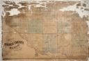
| Date: | 06 29 1941 |
|---|---|
| Description: | A map showing the national roots of the people of Wisconsin, based on the ethnic stock research by University of Wisconsin-Madison sociologist Prof. George... |
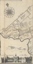
| Date: | |
|---|---|
| Description: | A detail of Philadelphia, including Mills Creek, Alms House and land ownership designations. |
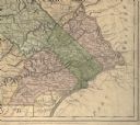
| Date: | 1775 |
|---|---|
| Description: | Detail of Pennsylvania map showing Chester, Philadelphia, and Bucks counties. |

| Date: | 1910 |
|---|---|
| Description: | Left half of a plat map of Hustisford in Dodge County. |

| Date: | 1910 |
|---|---|
| Description: | The right half of a plat map of Hustisford in Dodge County. |
| Date: | 1869 |
|---|---|
| Description: | Hand-drawn map of York County, South Carolina. |
If you didn't find the material you searched for, our Library Reference Staff can help.
Call our reference desk at 608-264-6535 or email us at: