 Filter: Categories of Wisconsin Historical Images
Filter: COLLECTION_NAME of Map Collection
Filter: County of Milwaukee
Filter: Categories of Wisconsin Historical Images
Filter: COLLECTION_NAME of Map Collection
Filter: County of Milwaukee

| Date: | 1936 |
|---|---|
| Description: | Color coded map in pink, yellow, blue, and brown of Milwaukee County State and County trunk highways. The map includes a legend of symbols: "STEAM RAIL ROA... |

| Date: | 1937 |
|---|---|
| Description: | Color coded map in pink, yellow, blue, and brown of Milwaukee County State and County trunk highways. The map includes a legend of symbols: "STEAM RAIL ROA... |

| Date: | 1941 |
|---|---|
| Description: | Color coded map in pink, yellow, green, and brown of Milwaukee County State and County trunk highways. The map includes a legend of symbols: "STEAM RAIL RO... |

| Date: | 1946 |
|---|---|
| Description: | Color coded map in pink, yellow, green, and brown of Milwaukee County State and County trunk highways. The map includes a legend of symbols: "STEAM RAIL RO... |
| Date: | 1925 |
|---|---|
| Description: | This map shows the routes of half-day and all-day trips from the Milwaukee area. The map highlights roads, land parcels, routes and destinations. Lake Mic... |

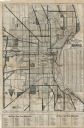
| Date: | 1928 |
|---|---|
| Description: | This map shows a view of the Milwaukee metropolitan area. It highlights state trunk highways, principal county trunks and other secondary highways and type... |

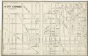
| Date: | 1910 |
|---|---|
| Description: | A Sanborn insurance map of a section of Milwaukee, including East Clybourn and East Buffalo Streets. "Italian Section 3/4/30" is written on the page in blu... |

| Date: | 1910 |
|---|---|
| Description: | A Sanborn insurance map of Milwaukee, including the shore of Lake Michigan. |

| Date: | 04 1926 |
|---|---|
| Description: | This blueprint map shows plats and includes water surface diagram and "history of the harbor." The Kinnickinnic River and the Milwaukee River are labelled.... |

| Date: | 1956 |
|---|---|
| Description: | This map shows city, suburban, parochial and other types schools, with an explanation of symbols in the right margin. The original caption for the map read... |

| Date: | 1966 |
|---|---|
| Description: | This map shows city, suburban, parochial and other types schools, with an explanation of symbols in the right margin. The original caption for the map read... |
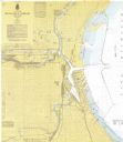
| Date: | 1967 |
|---|---|
| Description: | This map shows the harbor, streets, and some buildings. Also includes the Menomonee River, the Kinnickinnic River, the Municipal mooring Basin, and Lake Mi... |

| Date: | 1948 |
|---|---|
| Description: | This map shows the land parcels, streets, and parks near the harbor. It includes a wind chart and 7 cross sections of borings/probings and docks. It also i... |
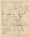
| Date: | 1970 |
|---|---|
| Description: | This blue line map shows zoning districts in the Village of Brown Deer. Includes a key in lower left hand corner. Includes street names. The Milwaukee Rive... |
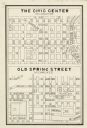
| Date: | 1940 |
|---|---|
| Description: | This map is pen and ink on paper and is map 2 in a series of 12. The map shows streets, the Milwaukee River, and railroad tracks. |
| Date: | 1940 |
|---|---|
| Description: | This map is pen and ink on paper and is map 3 in a series of 12. The map shows streets, the Milwaukee River, and railroad tracks. |
| Date: | 1940 |
|---|---|
| Description: | This map is pen and ink on paper and is map 3 in a series of 12. The map shows streets, and the Milwaukee River. |
| Date: | 1940 |
|---|---|
| Description: | This map is pen and ink on paper and is map 5 in a series of 12. The map shows streets, the Milwaukee River, Lake Michigan, and railroad tracks. |
| Date: | 1940 |
|---|---|
| Description: | This map is pen and ink on paper and is map 6 in a series of 12. The map shows streets, and the Milwaukee River. |
| Date: | 1940 |
|---|---|
| Description: | This map is pen and ink on paper and is map 7 in a series of 12. The map shows streets and a railroad line. |
If you didn't find the material you searched for, our Library Reference Staff can help.
Call our reference desk at 608-264-6535 or email us at: