 Filter: Categories of Wisconsin Historical Images
Filter: COLLECTION_NAME of Map Collection
Filter: Community of Madison
Filter: Categories of Wisconsin Historical Images
Filter: COLLECTION_NAME of Map Collection
Filter: Community of Madison
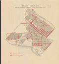
| Date: | 1916 |
|---|---|
| Description: | Shows streetlights, streets improvements, and sewer districts in red. Points of interest are labelled. Map reads: "Map of Tenth Ward Showing Improvements S... |

| Date: | 1917 |
|---|---|
| Description: | Shows property already platted (orange), public property (green), street railway (red lines), Lake Forest development area (red), and some landownership. T... |

| Date: | 1925 |
|---|---|
| Description: | Map produced by the Paul E. Stark Company to advertising sales and services. Bottom of the map features sales records for 1919 to 1925 and a paragraph read... |

| Date: | 1925 |
|---|---|
| Description: | Map produced by the Paul E. Stark Company to advertising sales and services. Bottom of the map features sales records for 1919 to 1925 and a paragraph read... |

| Date: | 1927 |
|---|---|
| Description: | Shows campus buildings, points of interest in surrounding area, and railroads. Advertisements on verso. |

| Date: | 1928 |
|---|---|
| Description: | Illustrated map of points of interest, including University buildings, parks, athletic venues, fraternity and sorority houses, and state buildings. |

| Date: | 1929 |
|---|---|
| Description: | This map is oriented with north to the upper right. Includes index of retailers and buildings, with some advertisements in margins. |

| Date: | 1929 |
|---|---|
| Description: | Shows fraternities, sororities, major rooming houses, private and university buildings, and university property. Oriented with north slightly to the right. |

| Date: | 1930 |
|---|---|
| Description: | Lower left hand corner reads: "Compliment of the Madison Association of Commerce MADISON The Four Lake City WISCONSIN." Around the perimeter of the map is ... |
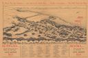
| Date: | 1929 |
|---|---|
| Description: | Bird’s-eye view map. Top of map reads: "To Show You the Campus ... and Gatewood's Book Store ... Further Instructions ... You Will Need No More". Bottom le... |

| Date: | 1934 |
|---|---|
| Description: | This map includes a street index. The map is oriented with the north toward the upper right. Includes handwritten annotations of the 1935 bus routes. |

| Date: | 1937 |
|---|---|
| Description: | Includes points of interests in Madison and on the University of Wisconsin-Madison campus. Includes list of presidents of University of Wisconsin, 1849-193... |
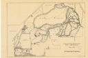
| Date: | 05 1938 |
|---|---|
| Description: | Map of the University of Wisconsin-Madison arboretum and wild life refuge. Roads are labelled, left to right: "Nakoma Road," "Monroe St.," "Manitou Way," "... |

| Date: | 1940 |
|---|---|
| Description: | Shows property ownership, store divisions, and bus stops. "Sept. 12, 1940." Oriented with north to the right. Insets: "Trade area" location map and enlarge... |

| Date: | 1930 |
|---|---|
| Description: | Indexed map of Madison. Streets, lakes, and points of interest are labelled. Around the edges of the map are the indexed street names. |

| Date: | 1943 |
|---|---|
| Description: | Shows Madison city limits with thick solid lines and ward districts with dotted lines. The wards are numbered, and points of interests and land marks are l... |

| Date: | 1948 |
|---|---|
| Description: | Map created between 1948 and 1954. Shows businesses and lot owners around the State Capitol. Oriented with north to the upper right. Includes "continued in... |

| Date: | 1950 |
|---|---|
| Description: | Includes building index and "To Help You Locate Buildings" text. Index includes campus buildings and points of interest. Aerial view on verso. |

| Date: | 1955 |
|---|---|
| Description: | Shows city limits, adjoining municipalities, and schools. Indexes, illustrations, ancillary map of Dane County, and ancillary map of Madison business secti... |

| Date: | 1956 |
|---|---|
| Description: | Map reads: "TAX EXEMPT LAND in the CITY OF MADISON". There is a legend of "Government Land" represented in stripes, "Religious and Fraternal Organization" ... |
If you didn't find the material you searched for, our Library Reference Staff can help.
Call our reference desk at 608-264-6535 or email us at: