Filter: Categories of Wisconsin Historical Images
Filter: COLLECTION_NAME of Map Collection
Filter: Creator Name of Unknown
Filter: Categories of Wisconsin Historical Images
Filter: COLLECTION_NAME of Map Collection
Filter: Creator Name of Unknown

| Date: | 1870 |
|---|---|
| Description: | Bird's-eye map of Madison. The Lakeside House resort is in the foreground, which burned in 1877, in what is now Olin Park. |

| Date: | 1868 |
|---|---|
| Description: | Bird's-eye map of Manitowoc, with four insets. Manitowoc County. |

| Date: | 1881 |
|---|---|
| Description: | Bird's-eye map of Milton Junction. |
| Date: | 1877 |
|---|---|
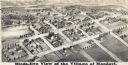
| Description: | Bird's-eye map of Mondovi. |

| Date: | 1890 |
|---|---|
| Description: | Bird's-eye map of West Superior and Superior, with insets of Wright Farm and First Building in Superior. |

| Date: | 1879 |
|---|---|
| Description: | This map is a bird's-eye view of Wausau, the County Seat of Marathon County. The map features an index of points of interest. |

| Date: | 1860 |
|---|---|
| Description: | Bird's-eye drawing of New Glarus. |

| Date: | 03 30 1835 |
|---|---|
| Description: | Map of township # 7N, range no. 10 east, 4th meridian, including Third Lake. |
| Date: | 1861 |
|---|---|
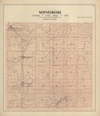
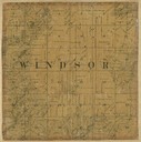
| Description: | Dane County plat map of the town of Windsor. |

| Date: | 1911 |
|---|---|
| Description: | Plat Map of Blooming Grove in "Atlas of Dane County, Wisconsin." |

| Date: | 1814 |
|---|---|
| Description: | Map of the Upper Territories of the United States. |

| Date: | 1832 |
|---|---|
| Description: | Route of Military Road from Fort Crawford to Fort Howard. Map shows beginning of route at Fort Crawford. |

| Date: | 1905 |
|---|---|
| Description: | Map of state of Idaho. Department of Interior General Land Office. |

| Date: | 1920 |
|---|---|
| Description: | A map of Madison and the vicinity. Red lines show the street railway. |

| Date: | 1879 |
|---|---|
| Description: | Map of Oconto and Marinette counties. |

| Date: | 1941 |
|---|---|
| Description: | Official highway map of Wisconsin, "the playground of the Midwest," showing the state transportation network prior to World War II. |

| Date: | 1856 |
|---|---|
| Description: | Isthmus of Madison, including Lake Mendota, or Great Lake, and Lake Menona [sic]. |
If you didn't find the material you searched for, our Library Reference Staff can help.
Call our reference desk at 608-264-6535 or email us at: