 Filter: Categories of Wisconsin Historical Images
Filter: COLLECTION_NAME of Map Collection
Filter: Creator Name of Bernsteen, Robert T.
Filter: Categories of Wisconsin Historical Images
Filter: COLLECTION_NAME of Map Collection
Filter: Creator Name of Bernsteen, Robert T.
| Date: | 1969 |
|---|---|
| Description: | This atlas consists of nine maps that show historic settlements, roads, archaeological features, logging, and railroads in Wisconsin counties. The maps are... |

| Date: | 01 1969 |
|---|---|
| Description: | A map of Oneida county, which includes a small drawing of a hodag. |
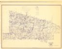
| Date: | 01 1969 |
|---|---|
| Description: | A map of Vilas county in northern Wisconsin. |
If you didn't find the material you searched for, our Library Reference Staff can help.
Call our reference desk at 608-264-6535 or email us at: