Filter: Categories of Wisconsin Historical Images
Filter: COLLECTION_NAME of Map Collection
Filter: Type of Photograph
Filter: Categories of Wisconsin Historical Images
Filter: COLLECTION_NAME of Map Collection
Filter: Type of Photograph
| Date: | 1671 |
|---|---|
| Description: | Photostat of map of Lac Tracy Ou Superieur (Lake Superior). Portions of Lac des Illinois (Lake Michigan) and Lac des Hurons (Lake Huron) are also shown. Gr... |
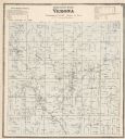
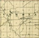
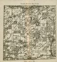
| Date: | 1873 |
|---|---|
| Description: | A map of Verona Township from the Dane County Atlas. |

| Date: | 1911 |
|---|---|
| Description: | A decorative page featuring Dane County public buildings, including a court house, a jail, the poor farm building, and two views of an asylum. |
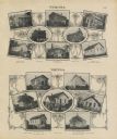
| Date: | 1911 |
|---|---|
| Description: | A decorative page with photographs of school buildings in the township of Verona and Vienna. Some of the photographs have groups of students with their tea... |

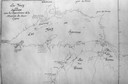
| Date: | 1849 |
|---|---|
| Description: | A hand-drawn map of showing the two proposed routes from the Milwaukee River to the Moody’s Lime Quarry at Milwaukee, Wisconsin. The map includes the route... |

| Date: | 1675 |
|---|---|
| Description: | Map of the southeast coast of North America from Jamestown to modern Georgia. It shows European settlements, Native American land and villages, coastal fea... |
| Date: | 1902 |
|---|---|
| Description: | A plat map of a portion of Lincoln County, showing Township 35 North, Range 8 East. |
If you didn't find the material you searched for, our Library Reference Staff can help.
Call our reference desk at 608-264-6535 or email us at: