Filter: Categories of Wisconsin Historical Images
Filter: COLLECTION_NAME of Map Collection
Filter: Type of Map or Atlas
Filter: Categories of Wisconsin Historical Images
Filter: COLLECTION_NAME of Map Collection
Filter: Type of Map or Atlas

| Date: | 1848 |
|---|---|
| Description: | In 1849, northern Wisconsin was composed of huge sectional regions such as Chippewa, Portage, Brown and Crawford, whereas southern Wisconsin was constitute... |

| Date: | 1856 |
|---|---|
| Description: | View looking west from Lake Michigan with several steam ships and sailing vessels in harbor. There is a lighthouse to left of center, along shoreline. |

| Date: | 1890 |
|---|---|
| Description: | Bird's-eye map of Ashland, viewed from Lake Superior, with insets of Prentice Park and Fishery. Population 16,000. Increase in Ten Years, 11,000. |

| Date: | 1861 |
|---|---|
| Description: | Drawn the first year of the Civil War, this colored 1861 map of Dane County shows its towns, cities and lakes. It includes insets of the wards of Madison a... |

| Date: | 1891 |
|---|---|
| Description: | Bird's-eye map of Wausau, looking north with ninety-eight businesses, industries, churches, schools, and civic buildings identified in location key below i... |

| Date: | 1886 |
|---|---|
| Description: | Bird's-eye view of Bayfield, county seat of Bayfield County. On the lower left side is an inset for Bayfield and the Apostle Islands. |

| Date: | 1885 |
|---|---|
| Description: | Bird's-eye view of Watertown with indexed points of interest. |

| Date: | 1862 |
|---|---|
| Description: | Drawn the second year of the Civil War, this 1862 map of Milwaukee shows post offices, light houses, beacon lights, county buildings, elevator warehouses, ... |

| Date: | 1890 |
|---|---|
| Description: | Portion of the plat map of the north part of Caledonia in Columbia County, including explanations. |

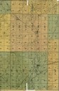
| Date: | 1890 |
|---|---|
| Description: | Plat map of the south part of Caledonia in Columbia County. |
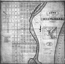
| Date: | 1836 |
|---|---|
| Description: | Map of Milwaukee including the Milwaukee River and Lake Michigan shore. |

| Date: | 1876 |
|---|---|
| Description: | Bird's-eye view of Black Earth. |

| Date: | 1867 |
|---|---|
| Description: | Birds-eye drawing of Appleton, Outagamie Co., depicting street names and street layout, houses, the Fox River, the court house, jail, school houses, Lawren... |

| Date: | 1910 |
|---|---|
| Description: | Map of Dane County rural delivery in Madison and the town of Westport. |

| Date: | 1836 |
|---|---|
| Description: | Map of all Dane County and eastern towns. |

| Date: | 1839 |
|---|---|
| Description: | This map shows the hydrology of Madison and its vicinity at the height of interest in a proposed Milwaukee and Rock River Canal. It was made by Thomas Jeff... |

| Date: | 1839 |
|---|---|
| Description: | A map of the Wiskonsin [sic] and Neenah or Fox Rivers. |
If you didn't find the material you searched for, our Library Reference Staff can help.
Call our reference desk at 608-264-6535 or email us at: