Filter: Categories of Wisconsin Historical Images
Filter: COLLECTION_NAME of Library Collection
Filter: Subject of rivers
Filter: Categories of Wisconsin Historical Images
Filter: COLLECTION_NAME of Library Collection
Filter: Subject of rivers

| Date: | |
|---|---|
| Description: | A Menominee Indian Village on Wolf River. There are dwellings on the shore and many people in canoes are on the river. |
| Date: | 1855 |
|---|---|
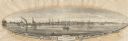
| Description: | View of Detroit with several boats and ships in (probably) the Detroit River. |
| Date: | 1888 |
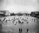
|---|---|
| Description: | Elevated view of a winter scene with a large group of people skating on the frozen Manitowoc River between the 8th and 10th Street bridges. A dog trots acr... |
| Date: | 1900 |
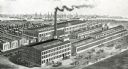
|---|---|
| Description: | Engraved bird's-eye view of the wood shop, warehouse, machine shop, dry kilns, and foundry of the Manitowoc Seating Company. Several people pass in front o... |
| Date: | |
|---|---|
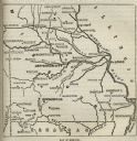
| Description: | Map of Missouri with major cities, rivers, and railroads marked. |
| Date: | 1887 |
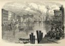
|---|---|
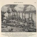
| Description: | Engraving of Pittsburg Landing taken from a photograph a few days after the Battle of Shiloh (Tennessee), which occurred on April 6-7, 1862. The image sho... |

| Date: | 1851 |
|---|---|
| Description: | Map of a portion of Merton including the Bark River, a mill, Fort Hill, and Indian mounds. |
| Date: | 1874 |
|---|---|
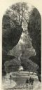
| Description: | Engraved view of Rood's Glen. A boy plays with a toy boat at bottom left while two men and a woman talk at bottom right. Two other figures can be seen in t... |
| Date: | 1888 |
|---|---|
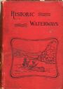
| Description: | Front cover of Reuben Gold Thwaites' Historic Waterways, with an image of a man and a woman paddling a rowboat on a river. |

| Date: | 1887 |
|---|---|
| Description: | Map of the Fox and Wisconsin Rivers to accompany Reuben Gold Thwaites' Historic Waterways. |

| Date: | 1850 |
|---|---|
| Description: | Map showing Indian mounds and graves as well as ground cover types at Township 8, Range 22. There is an inset diagram of an effigy mound labeled "The Cross... |

| Date: | 1828 |
|---|---|
| Description: | Map of the Louisville and Portland Canal on the Ohio River. The map shows Louisville, Shippingsport, Clarksville, Jeffersonville, Gravel Island, Corn Islan... |

| Date: | 1937 |
|---|---|
| Description: | Map showing territory controlled by the Finches, a family of bandits who terrorized south central Wisconsin in the years prior to the Civil War. The map in... |

| Date: | 1886 |
|---|---|
| Description: | View across water towards the George Whiting Paper Mill on the Lawson Canal. |

| Date: | 1900 |
|---|---|
| Description: | A hand-drawn map of the battlefield of the Battle of Chickamauga. |
If you didn't find the material you searched for, our Library Reference Staff can help.
Call our reference desk at 608-264-6535 or email us at: