 Filter: Categories of Wisconsin Historical Images
Filter: COLLECTION_NAME of Library Collection
Filter: Subject of maps
Filter: Categories of Wisconsin Historical Images
Filter: COLLECTION_NAME of Library Collection
Filter: Subject of maps
| Date: | 06 1930 |
|---|---|
| Description: | A map of the western states showing "public playlands," mostly national parks. |
| Date: | |
|---|---|
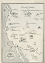
| Description: | Hand-drawn map of the location of the Fox Indian Wars. |
| Date: | 1951 |
|---|---|
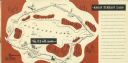
| Description: | A drawing of the 5.3 mile race course around Elkhart Lake. Page 12 and 13 of the official program from Elkhart Lake Road Race. The race took place on Sunda... |
| Date: | 1862 |
|---|---|
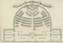
| Description: | Diagram and seating chart for the Wisconsin State Assembly. |

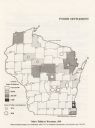
| Date: | 1936 |
|---|---|
| Description: | Two maps of Wisconsin showing foreign born populations by county in 1890 and 1910. |
| Date: | 1920 |
|---|---|
| Description: | Map of Wisconsin showing native Polish populations by county. |
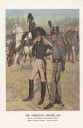
| Date: | 1976 |
|---|---|
| Description: | "A general staff officer stands in the left foreground in the single-breasted blue coat with black herringbone false buttonholes on the chest and cuffs and... |

| Date: | 1952 |
|---|---|
| Description: | Map of the barley-growing regions of North America, published by the Rahr Malting Company, Manitowoc, Wisconsin, 1952. |

| Date: | 1937 |
|---|---|
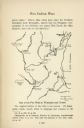
| Description: | Map showing territory controlled by the Finches, a family of bandits who terrorized south central Wisconsin in the years prior to the Civil War. The map in... |
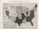
| Date: | 03 23 1912 |
|---|---|
| Description: | A map showing proportions of women's suffrage in the United States. |

| Date: | 1866 |
|---|---|
| Description: | Diagram and seating chart for the Wisconsin State Senate in the second State Capitol Building which burned down in 1904. |

| Date: | 1866 |
|---|---|
| Description: | Diagram and seating chart for the Wisconsin State Assembly in the second State Capitol Building which burned down in 1904.. |
If you didn't find the material you searched for, our Library Reference Staff can help.
Call our reference desk at 608-264-6535 or email us at: