 Filter: Categories of Wisconsin Historical Images
Filter: COLLECTION_NAME of John Newhouse photographs, interviews and other materials, 1945-1974
Filter: Year of 1900-1999
Filter: Year of 1960-1969
Filter: Categories of Wisconsin Historical Images
Filter: COLLECTION_NAME of John Newhouse photographs, interviews and other materials, 1945-1974
Filter: Year of 1900-1999
Filter: Year of 1960-1969
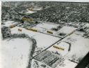
| Date: | 1965 |
|---|---|
| Description: | Aerial view of the UW-Madison campus near University Bay in winter. Labels are pasted to the print to indicate Elm Dr., the gym, Camp Randall Stadium, the ... |

| Date: | 1962 |
|---|---|
| Description: | John Newhouse, staff photographer for the "Wisconsin State Journal," in a “shooting session” with model Jean Harris. Ms. Harris is, for some unexplained re... |

| Date: | 06 1960 |
|---|---|
| Description: | Model standing in front of 3209 Kingston Drive, a demonstration residence at the 1960 “Parade of Homes” promotional event. |

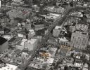
| Date: | 1960 |
|---|---|
| Description: | View looking down on Pinckney Street, with a section of Capitol park, from the Belmont Hotel. |

| Date: | 1965 |
|---|---|
| Description: | Interior portrait of a farmer and his wife sitting on chairs and eating off paper plates in their laps. There are containers of "Meadow Gold" on their plat... |

| Date: | 1968 |
|---|---|
| Description: | Aerial view looking southwest, with Lake Mendota at right and East Gorham Street running from the bottom left corner. Lincoln School is in the foreground, ... |

| Date: | 1960 |
|---|---|
| Description: | Air view of the Lake Mendota Shore looking east. The Edgewater Hotel and Kennedy Manor are at bottom center with Lake Mendota at left. James Madison Park i... |

| Date: | 1962 |
|---|---|
| Description: | Air view in winter of the Triangle Redevelopment Project looking east with Regent Street running along the left edge, W. Washington Avenue along the top, a... |

| Date: | 06 1960 |
|---|---|
| Description: | Aerial view looking northwest showing an area to be redeveloped into high-rise dormitories. Lake Mendota and Bascom Woods can be seen at the top. Universit... |

| Date: | 03 1962 |
|---|---|
| Description: | Aerial view with beginning of construction on Sellery Hall on the block bounded by Park, West Johnson, Murray, and West Dayton Streets. Park Street runs fr... |

| Date: | 1965 |
|---|---|
| Description: | Air view of the west end of University of Wisconsin-Madison campus with U.W. Hospital and U.W. athletic fields at top. Campus Drive and University Avenue r... |

| Date: | 1968 |
|---|---|
| Description: | Air view of the University of Wisconsin-Madison campus looking north to Lake Mendota. Picnic Point, currently part of the Lakeshore Nature Preserve, and Ca... |

| Date: | 1962 |
|---|---|
| Description: | Aerial view of the Hilldale Shopping Center and environs. Anchor store is Gimbels. N. Midvale Boulevard runs left to right. The State Department of Transpo... |

| Date: | 1967 |
|---|---|
| Description: | Air view looking north toward Lake Mendota. The intersection of West Washington Ave. and S. Park Street is at bottom center. The Triangle Redevelopment Pro... |

| Date: | 1960 |
|---|---|
| Description: | Air view focused on the Greenbush neighborhood of Madison prior to its demolition for the Triangle Redevelopment Project. Monona Bay and Brittingham Park a... |
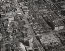
| Date: | 1963 |
|---|---|
| Description: | Aerial view of downtown Madison focused on Mifflin and Fairchild Streets with the site of the new Madison Public Library marked. Mifflin Street runs diagon... |
| Date: | 1963 |
|---|---|
| Description: | Aerial view showing University Avenue running diagonally from top to bottom. Chadbourne Hall at the intersection of University and N. Park Street is at bot... |

| Date: | 1964 |
|---|---|
| Description: | Aerial view of the Sampson Plaza apartment complex on West Washington Avenue, with Proudfit Street running along the bottom. Neighborhood House can be seen... |
If you didn't find the material you searched for, our Library Reference Staff can help.
Call our reference desk at 608-264-6535 or email us at: