 Filter: Categories of Wisconsin Historical Images
Filter: COLLECTION_NAME of John Newhouse photographs, interviews and other materials, 1945-1974
Filter: Subject of transportation
Filter: Categories of Wisconsin Historical Images
Filter: COLLECTION_NAME of John Newhouse photographs, interviews and other materials, 1945-1974
Filter: Subject of transportation

| Date: | 1954 |
|---|---|
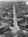
| Description: | Elevated view from the Wisconsin State Capitol looking west up State Street toward the University of Wisconsin. Frozen Lake Monona is on the right. |
| Date: | 1959 |
|---|---|
| Description: | Elevated view of State Street from the Wisconsin State Capitol building. Lake Mendota is on the far right. |
| Date: | |
|---|---|
| Description: | Aerial view of Madison, including the Capitol Square on the left at Mifflin and State Street, and Central High School, the light-colored building in the fo... |

| Date: | |
|---|---|
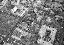
| Description: | Aerial view of the Capitol Square, with Capitol Park and part of the Wisconsin State Capitol. Manchester's is on the corner of Mifflin Street at Wisconsin ... |

| Date: | |
|---|---|
| Description: | Aerial view of Madison featuring Central High School/Madison Area Technical College (MATC) at top center. |
| Date: | 1957 |
|---|---|
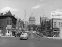
| Description: | View up State Street towards the Wisconsin State Capitol taken from the West Johnson Street intersection. Businesses include the Orpheum Theatre, Arenz, an... |

| Date: | 07 07 1954 |
|---|---|
| Description: | Aerial view of group of buildings on the north east campus of the University of Wisconsin, including the Historical Library, University Library, old Scienc... |

| Date: | 1945 |
|---|---|
| Description: | An aerial view, looking northeast, that includes the intersection at Atwood and Fair Oaks Avenues. Elmside Circle Park is on the bottom left. The Madison-K... |

| Date: | |
|---|---|
| Description: | Aerial view over Monona Bay showing two railroads crossing in the center. Olin Park is on the top left. |

| Date: | 1968 |
|---|---|
| Description: | Aerial view looking southwest, with Lake Mendota at right and East Gorham Street running from the bottom left corner. Lincoln School is in the foreground, ... |

| Date: | 1960 |
|---|---|
| Description: | Air view of the Lake Mendota Shore looking east. The Edgewater Hotel and Kennedy Manor are at bottom center with Lake Mendota at left. James Madison Park i... |

| Date: | 1962 |
|---|---|
| Description: | Air view in winter of the Triangle Redevelopment Project looking east with Regent Street running along the left edge, W. Washington Avenue along the top, a... |

| Date: | 06 1960 |
|---|---|
| Description: | Aerial view looking northwest showing an area to be redeveloped into high-rise dormitories. Lake Mendota and Bascom Woods can be seen at the top. Universit... |

| Date: | 03 1962 |
|---|---|
| Description: | Aerial view with beginning of construction on Sellery Hall on the block bounded by Park, West Johnson, Murray, and West Dayton Streets. Park Street runs fr... |

| Date: | 1965 |
|---|---|
| Description: | Air view of the west end of University of Wisconsin-Madison campus with U.W. Hospital and U.W. athletic fields at top. Campus Drive and University Avenue r... |

| Date: | 1968 |
|---|---|
| Description: | Air view of the University of Wisconsin-Madison campus looking north to Lake Mendota. Picnic Point, currently part of the Lakeshore Nature Preserve, and Ca... |

| Date: | 1962 |
|---|---|
| Description: | Aerial view of the Hilldale Shopping Center and environs. Anchor store is Gimbels. N. Midvale Boulevard runs left to right. The State Department of Transpo... |

| Date: | 1967 |
|---|---|
| Description: | Air view looking north toward Lake Mendota. The intersection of West Washington Ave. and S. Park Street is at bottom center. The Triangle Redevelopment Pro... |

| Date: | 1960 |
|---|---|
| Description: | Air view focused on the Greenbush neighborhood of Madison prior to its demolition for the Triangle Redevelopment Project. Monona Bay and Brittingham Park a... |

| Date: | |
|---|---|
| Description: | Aerial view of the Greenbush neighborhood in winter partially demolished for the Triangle Redevelopment Project. Monona Bay and Brittingham park are at rig... |
If you didn't find the material you searched for, our Library Reference Staff can help.
Call our reference desk at 608-264-6535 or email us at: