 Filter: Categories of Wisconsin Historical Images
Filter: COLLECTION_NAME of John Newhouse photographs, interviews and other materials, 1945-1974
Filter: Subject of roads
Filter: Categories of Wisconsin Historical Images
Filter: COLLECTION_NAME of John Newhouse photographs, interviews and other materials, 1945-1974
Filter: Subject of roads

| Date: | 1956 |
|---|---|
| Description: | Aerial view of the South Park Street interchange. |
| Date: | 1954 |
|---|---|
| Description: | Elevated view of State Street looking toward Bascom Hall and the University of Wisconsin-Madison campus from the Wisconsin State Capitol dome. |

| Date: | 06 07 1954 |
|---|---|
| Description: | Aerial view of the Midvale neighborhood under construction showing the intersection of Midvale and Tokay Boulevards near the southwestern city limits of Ma... |

| Date: | 06 07 1954 |
|---|---|
| Description: | Aerial view looking north from near the city's southwestern limits in 1954. Shows text indicating Midvale Boulevard, Odana Road, Tokay Boulevard, Mineral P... |

| Date: | 1955 |
|---|---|
| Description: | Aerial view of Midvale neighborhood under construction near Madison's southwestern city limits. The view is focused on the area bounded by Tokay Boulevard,... |
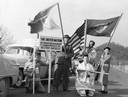
| Date: | 10 1956 |
|---|---|
| Description: | Glenn Turner is holding the United Nations flag, and his wife is carrying the flag of the state of Wisconsin. A supporter is holding the American flag. One... |

| Date: | 1955 |
|---|---|
| Description: | Air view of University Avenue at Midvale Boulevard. |

| Date: | 1955 |
|---|---|
| Description: | Aerial view of the central traffic loop and Johnson Street expressway. |

| Date: | 1955 |
|---|---|
| Description: | Aerial view of the Illinois central route. The UW Fieldhouse is visible in the lower right of the image. |

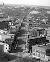
| Date: | 1955 |
|---|---|
| Description: | Elevated view of Capitol Square, looking northwest up Carroll Street at its intersection with Main Street. |

| Date: | |
|---|---|
| Description: | Aerial view of the southeast, with West Broadway and the South Beltline running through the image. Also shows Nob Hill restaurant, the Toki family farm and... |

| Date: | |
|---|---|
| Description: | Aerial view of a full Camp Randall Stadium during half-time of a football game. The band is on the field in formation to spell "UW." |

| Date: | 1955 |
|---|---|
| Description: | Blacktopping a new Madison residential street. Construction of the ranch-style houses in the background is almost complete. |
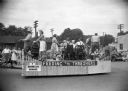
| Date: | 1955 |
|---|---|
| Description: | The Brooklyn Grange parade float in a Labor Day parade. Men and women on the float mimic various household and recreational activities. |

| Date: | 1956 |
|---|---|
| Description: | Aerial view of Wisconsin General Hospital. |

| Date: | 1955 |
|---|---|
| Description: | Aerial view of Schenk's Corners where Atwood Avenue and Winnebago Street cross, looking north west toward East Washington Avenue. ... |
| Date: | 1945 |
|---|---|
| Description: | Aerial view of Schenk's Corners looking east showing the intersection of Atwood Avenue and Winnebago Street. |

| Date: | 1956 |
|---|---|
| Description: | Aerial view of Schenk's Corners where Atwood Avenue and Winnebago Street cross, looking north east. |

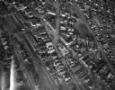
| Date: | 1956 |
|---|---|
| Description: | Aerial view of residential homes, farmland and streets. |

| Date: | 1957 |
|---|---|
| Description: | View from inside front seat of an automobile looking toward intersection of Midvale Avenue and Odana Road. |
If you didn't find the material you searched for, our Library Reference Staff can help.
Call our reference desk at 608-264-6535 or email us at: