Filter: Categories of Wisconsin Historical Images
Filter: COLLECTION_NAME of John Newhouse photographs, interviews and other materials, 1945-1974
Filter: Subject of lakes
Filter: Categories of Wisconsin Historical Images
Filter: COLLECTION_NAME of John Newhouse photographs, interviews and other materials, 1945-1974
Filter: Subject of lakes
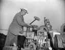
| Date: | 1948 |
|---|---|
| Description: | John Roach, director of the state beverage and cigarette tax division, using a sledge hammer to smash illegal slot machines. |

| Date: | 06 07 1954 |
|---|---|
| Description: | Aerial view looking north from near the city's southwestern limits in 1954. Shows text indicating Midvale Boulevard, Odana Road, Tokay Boulevard, Mineral P... |
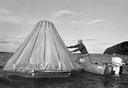
| Date: | 1950 |
|---|---|
| Description: | A man sets up a cone-shaped instrument designed to distill fresh water from salt water as he leans out of a small motor boat on the water. |

| Date: | |
|---|---|
| Description: | Aerial view of the southeast, with West Broadway and the South Beltline running through the image. Also shows Nob Hill restaurant, the Toki family farm and... |

| Date: | 1955 |
|---|---|
| Description: | An aerial view of Middleton. In the foreground is a baseball field, and beyond are houses, woods, fields, and Lake Mendota. |

| Date: | 07 15 1958 |
|---|---|
| Description: | Aerial view of Eagle Heights Farm, Eagle Heights Woods and part of Lake Mendota. Sites labeled on the image are Eagle Heights, Tent Colony, Apartment Site,... |
| Date: | 1965 |
|---|---|
| Description: | Aerial view of the UW-Madison campus near University Bay in winter. Labels are pasted to the print to indicate Elm Dr., the gym, Camp Randall Stadium, the ... |

| Date: | |
|---|---|
| Description: | An aerial view of Governor's Island. A cutout of an arrow has been added. |

| Date: | 1954 |
|---|---|
| Description: | Aerial view of the west side of Madison showing newly constructed homes and homes under construction featured in the Parade of Homes. The main road through... |

| Date: | 1954 |
|---|---|
| Description: | Elevated view from the Wisconsin State Capitol looking west up State Street toward the University of Wisconsin. Frozen Lake Monona is on the right. |
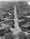
| Date: | 1959 |
|---|---|
| Description: | Elevated view of State Street from the Wisconsin State Capitol building. Lake Mendota is on the far right. |

| Date: | 07 07 1954 |
|---|---|
| Description: | Aerial view of group of buildings on the north east campus of the University of Wisconsin, including the Historical Library, University Library, old Scienc... |

| Date: | |
|---|---|
| Description: | Aerial view over Monona Bay showing two railroads crossing in the center. Olin Park is on the top left. |

| Date: | 1968 |
|---|---|
| Description: | Aerial view looking southwest, with Lake Mendota at right and East Gorham Street running from the bottom left corner. Lincoln School is in the foreground, ... |

| Date: | 1960 |
|---|---|
| Description: | Air view of the Lake Mendota Shore looking east. The Edgewater Hotel and Kennedy Manor are at bottom center with Lake Mendota at left. James Madison Park i... |

| Date: | 06 1960 |
|---|---|
| Description: | Aerial view looking northwest showing an area to be redeveloped into high-rise dormitories. Lake Mendota and Bascom Woods can be seen at the top. Universit... |

| Date: | 1968 |
|---|---|
| Description: | Air view of the University of Wisconsin-Madison campus looking north to Lake Mendota. Picnic Point, currently part of the Lakeshore Nature Preserve, and Ca... |

| Date: | 1962 |
|---|---|
| Description: | Aerial view of the Hilldale Shopping Center and environs. Anchor store is Gimbels. N. Midvale Boulevard runs left to right. The State Department of Transpo... |

| Date: | 1967 |
|---|---|
| Description: | Air view looking north toward Lake Mendota. The intersection of West Washington Ave. and S. Park Street is at bottom center. The Triangle Redevelopment Pro... |
If you didn't find the material you searched for, our Library Reference Staff can help.
Call our reference desk at 608-264-6535 or email us at: