 Filter: Categories of Wisconsin Historical Images
Filter: COLLECTION_NAME of John Newhouse photographs, interviews and other materials, 1945-1974
Filter: Subject of central business districts
Filter: Categories of Wisconsin Historical Images
Filter: COLLECTION_NAME of John Newhouse photographs, interviews and other materials, 1945-1974
Filter: Subject of central business districts
| Date: | 1954 |
|---|---|
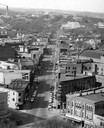
| Description: | Elevated view of State Street looking toward Bascom Hall and the University of Wisconsin-Madison campus from the Wisconsin State Capitol dome. |
| Date: | 1954 |
|---|---|
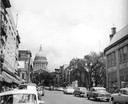
| Description: | A view down State Street looking towards the Wisconsin State Capitol. |
| Date: | 1954 |
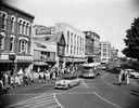
|---|---|
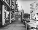
| Description: | King Street, looking past the Majestic Theater, with the Wisconsin State Capitol in the background. |

| Date: | 1958 |
|---|---|
| Description: | Aerial view of the Wisconsin State Capitol and surrounding area. The view is looking northwest, with King Street on the bottom right, and S. Hamilton Stree... |

| Date: | 1950 |
|---|---|
| Description: | Mounted on a ladder, a man is poised to empty a bucket onto the open umbrella of a man sitting on a sidewalk bench. |

| Date: | 1955 |
|---|---|
| Description: | Air view of University Avenue at Midvale Boulevard. |
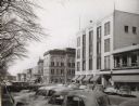
| Date: | 1954 |
|---|---|
| Description: | View looking west down Mifflin Street showing the old City Hall, the Parkway Theater, and Manchesters Department Store. Automobiles are parked at an angle ... |
| Date: | 1952 |
|---|---|
| Description: | Slightly elevated view of a parade on the Capitol Square, celebrating a visit by Adlai Stevenson, Democratic candidate for President. |

| Date: | 1953 |
|---|---|
| Description: | Aerial view looking southeast over Madison's near east side. The Eagles Club at 1236 Jenifer Street / 1221 Williamson Street is under construction in the ... |

| Date: | 1955 |
|---|---|
| Description: | Aerial view of the central traffic loop and Johnson Street expressway. |

| Date: | 1955 |
|---|---|
| Description: | Aerial view of the Illinois central route. The UW Fieldhouse is visible in the lower right of the image. |
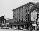
| Date: | 1954 |
|---|---|
| Description: | F.W. Woolworth store on East Main Street at Monona Avenue (now Martin Luther King, Jr., Boulevard), showing the old Vilas block (aka Pioneer Building). |

| Date: | 1955 |
|---|---|
| Description: | Aerial view of Schenk's Corners where Atwood Avenue and Winnebago Street cross, looking north west toward East Washington Avenue. ... |
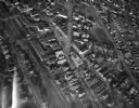
| Date: | 1945 |
|---|---|
| Description: | Aerial view of Schenk's Corners looking east showing the intersection of Atwood Avenue and Winnebago Street. |

| Date: | 1956 |
|---|---|
| Description: | Aerial view of Schenk's Corners where Atwood Avenue and Winnebago Street cross, looking north east. |
| Date: | |
|---|---|
| Description: | Aerial view of Madison, including the Capitol Square on the left at Mifflin and State Street, and Central High School, the light-colored building in the fo... |

| Date: | |
|---|---|
| Description: | Aerial view of the Capitol Square, with Capitol Park and part of the Wisconsin State Capitol. Manchester's is on the corner of Mifflin Street at Wisconsin ... |

| Date: | |
|---|---|
| Description: | Aerial view of Madison featuring Central High School/Madison Area Technical College (MATC) at top center. |

| Date: | 1945 |
|---|---|
| Description: | An aerial view, looking northeast, that includes the intersection at Atwood and Fair Oaks Avenues. Elmside Circle Park is on the bottom left. The Madison-K... |
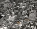
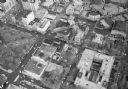
| Date: | 1963 |
|---|---|
| Description: | Aerial view of downtown Madison focused on Mifflin and Fairchild Streets with the site of the new Madison Public Library marked. Mifflin Street runs diagon... |
If you didn't find the material you searched for, our Library Reference Staff can help.
Call our reference desk at 608-264-6535 or email us at: