 Filter: Categories of Wisconsin Historical Images
Filter: COLLECTION_NAME of John Newhouse photographs, interviews and other materials, 1945-1974
Filter: County of Dane
Filter: Subject of intellectual life
Filter: Categories of Wisconsin Historical Images
Filter: COLLECTION_NAME of John Newhouse photographs, interviews and other materials, 1945-1974
Filter: County of Dane
Filter: Subject of intellectual life

| Date: | 1956 |
|---|---|
| Description: | Aerial view of the South Park Street interchange. |

| Date: | 1958 |
|---|---|
| Description: | Aerial view of the Wisconsin State Capitol and surrounding area. The view is looking northwest, with King Street on the bottom right, and S. Hamilton Stree... |

| Date: | 06 07 1954 |
|---|---|
| Description: | Aerial view of the Midvale neighborhood under construction showing the intersection of Midvale and Tokay Boulevards near the southwestern city limits of Ma... |

| Date: | 06 07 1954 |
|---|---|
| Description: | Aerial view looking north from near the city's southwestern limits in 1954. Shows text indicating Midvale Boulevard, Odana Road, Tokay Boulevard, Mineral P... |

| Date: | 1955 |
|---|---|
| Description: | Aerial view of Midvale neighborhood under construction near Madison's southwestern city limits. The view is focused on the area bounded by Tokay Boulevard,... |

| Date: | 1956 |
|---|---|
| Description: | Aerial view of the Chicago, Milwaukee, and St. Paul Railroad station, roundhouse, and yard at the intersection of West Washington Avenue (across lower left... |
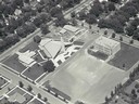
| Date: | |
|---|---|
| Description: | Aerial view of Our Lady Queen of Peace Church. |
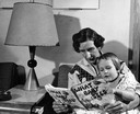
| Date: | 1950 |
|---|---|
| Description: | A young child examines a children's book with her grandmother. |
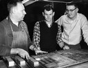
| Date: | 1950 |
|---|---|
| Description: | Sports editor and sports reporter from the "Wisconsin State Journal" confer with a printer over trays of lead type. |
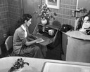
| Date: | 1950 |
|---|---|
| Description: | A woman writes a note at a small writing desk in her kitchen. |
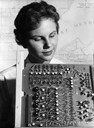
| Date: | 1950 |
|---|---|
| Description: | Jean Hoffman looks over a printed circuit board in the foreground, with a map of Madison, Wisconsin on the wall behind her. |

| Date: | 1953 |
|---|---|
| Description: | Aerial view looking southeast over Madison's near east side. The Eagles Club at 1236 Jenifer Street / 1221 Williamson Street is under construction in the ... |

| Date: | 1955 |
|---|---|
| Description: | Aerial view of the central traffic loop and Johnson Street expressway. |

| Date: | 1955 |
|---|---|
| Description: | Aerial view of the Illinois central route. The UW Fieldhouse is visible in the lower right of the image. |

| Date: | |
|---|---|
| Description: | Aerial view of the southeast, with West Broadway and the South Beltline running through the image. Also shows Nob Hill restaurant, the Toki family farm and... |

| Date: | |
|---|---|
| Description: | Aerial view of a full Camp Randall Stadium during half-time of a football game. The band is on the field in formation to spell "UW." |

| Date: | |
|---|---|
| Description: | Aerial view of Union Corners intersection of East Washington Avenue, Milwaukee Street and North Street looking north. The Rayovac building is in the foregr... |
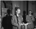
| Date: | 1952 |
|---|---|
| Description: | Adlai Stevenson, Democratic Presidential candidate, at a podium speaking to an audience. To Stevenson's right is Thomas Fairchild, the Democratic candidat... |

| Date: | 03 17 1952 |
|---|---|
| Description: | Owen D. Lattimore speaking to an audience. Although the photograph is not identified, it was undoubtedly taken at an appearance at the University Union Th... |

| Date: | 1956 |
|---|---|
| Description: | Aerial view of Wisconsin General Hospital. |
If you didn't find the material you searched for, our Library Reference Staff can help.
Call our reference desk at 608-264-6535 or email us at: