 Filter: Categories of Wisconsin Historical Images
Filter: COLLECTION_NAME of Draper manuscripts
Filter: Creator Name of Unknown
Filter: Categories of Wisconsin Historical Images
Filter: COLLECTION_NAME of Draper manuscripts
Filter: Creator Name of Unknown
| Date: | |
|---|---|
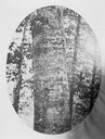
| Description: | A beech tree with the inscription, "D. Boon cilled a bar. 1760" carved into it. The tree was located up to the 1880s near Boone's Creek, Tennessee. |
| Date: | |
|---|---|
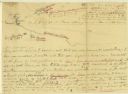
| Description: | A hand-drawn map of the Boone camps on the Kentucky River. |

| Date: | 11 26 1883 |
|---|---|
| Description: | A hand-drawn map of the Clinch and Powell's Valleys, including the Cumberland Mountains, Powell's Mountains and Clinch Mountains. |

| Date: | |
|---|---|
| Description: | A hand-drawn map including the location of Daniel Boone's home and two forts, northeast of Lexington, Kentucky. |

| Date: | |
|---|---|
| Description: | A hand-drawn map of Indian boundary lines in southwest Virginia. It also includes the Duck River and the Elk River. |
| Date: | |
|---|---|
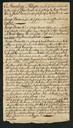
| Description: | Handwritten letter of genealogical information about the Boone family. |
If you didn't find the material you searched for, our Library Reference Staff can help.
Call our reference desk at 608-264-6535 or email us at: