Filter: Categories of Wisconsin Historical Images
Filter: COLLECTION_NAME of Commonplace Structures in Southern Wisconsin
Filter: Year of 1900-1999
Filter: Categories of Wisconsin Historical Images
Filter: COLLECTION_NAME of Commonplace Structures in Southern Wisconsin
Filter: Year of 1900-1999

| Date: | 1980 |
|---|---|
| Description: | Shadow of billboard sign towers over the parking lot of the U-Haul 'U-Move, U-Store' Center on West Platte Drive. |

| Date: | 1980 |
|---|---|
| Description: | Elevated view of construction and development taking place in a housing community known as Tamarack Trails Subdivision. |

| Date: | 1980 |
|---|---|
| Description: | Front view of a house under construction in the Tamarack Trails Subdivision. |

| Date: | 11 1980 |
|---|---|
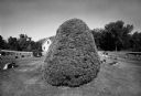
| Description: | A telephone pole emerges from a dirt mound and casts a shadow across the land. Trees and a water tower can be seen in the distance. Bible Camp Road. |

| Date: | 11 1980 |
|---|---|
| Description: | Presumably the back side of a service station located at 2663 South Stoughton Road, south of McFarland. |
| Date: | 06 22 1978 |
|---|---|
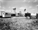
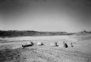
| Description: | View of carnival with a water tower in the background. There are trailers, and a carousel is on the left. Carts selling food like popcorn and sausage are p... |

| Date: | 11 18 1979 |
|---|---|
| Description: | An electrical box on a wooden pole is in the center foreground. Behind it is a street, and on the other side of the street is a Phillips 66 service station... |
| Date: | 1980 |
|---|---|
| Description: | Landscape view of a subdivision. In the center is an electrical meter, stone walls, and pine trees. In the distance are houses and telephone poles. |

| Date: | 12 1980 |
|---|---|
| Description: | A large shadow from a cement wall is cast over the parking lot to Clark Gas Station at 2422 West Capitol Drive. A billboard for Coronet VSQ Brandy is mount... |
| Date: | 1980 |
|---|---|
| Description: | Roads and telephone lines intersect at the corner of the block, 4021 North 62nd (Rear). |

| Date: | 03 1980 |
|---|---|
| Description: | A vacant parking lot accompanies the now Imperial Garden Restaurant (formally Villa Piazza), 2039 Allen Boulevard. |
| Date: | 03 1981 |
|---|---|
| Description: | View of cement foundations and pillars for a future sewer pipeline. Cedar Ridge Subdivision. |

| Date: | 03 24 1980 |
|---|---|
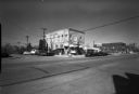
| Description: | A birch tree is in the center foreground. Behind it is a municipal parking lot with an automobile parked in it near the storefront of Neubauer's Sporting G... |

| Date: | 04 1981 |
|---|---|
| Description: | A grand horseshoe-shaped staircase in the center of the entrance to this Grecian-style building on Highway 151. The Hospital and home stand tall with large... |

| Date: | 04 21 1980 |
|---|---|
| Description: | Across a street leading to 51 is a parking lot with a single automobile parked in a lot near a church. Across the street to the left is a Shell gas station... |
| Date: | 04 1981 |
|---|---|
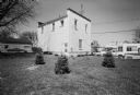
| Description: | Exterior view from lawn of a white brick bank. Tiny evergreen trees are planted outside and cars are parked alongside the road. |

| Date: | 04 1981 |
|---|---|
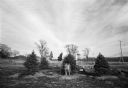
| Description: | View of the Graceland Cemetery. There are houses in the background and trees scattered throughout the plots. |
| Date: | 04 1981 |
|---|---|
| Description: | View across street of parked cars along curb in front of the Suburban Inn, formerly the Park Hotel, on the 300 block of Broom Street. Next door on the righ... |

| Date: | 05 1981 |
|---|---|
| Description: | View from across street of house on 2051 Camilla Street. |
If you didn't find the material you searched for, our Library Reference Staff can help.
Call our reference desk at 608-264-6535 or email us at: