Filter: Categories of Wisconsin Historical Images
Filter: COLLECTION_NAME of Commonplace Structures in Southern Wisconsin
Filter: Subject of botany
Filter: Subject of transportation
Filter: Categories of Wisconsin Historical Images
Filter: COLLECTION_NAME of Commonplace Structures in Southern Wisconsin
Filter: Subject of botany
Filter: Subject of transportation
| Date: | 01 1981 |
|---|---|
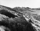
| Description: | Empty snowy plains soon to be turned into Rt. 81. Hills and a few poles are in the far distance. |
| Date: | 04 1980 |
|---|---|
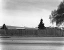
| Description: | View across stateline road towards a wooden fence lining the road on the opposite side. A few trees and buildings can be seen over the fence. |

| Date: | 1980 |
|---|---|
| Description: | Four arches reach above decorative thatched windows on a Spanish style building, which was known as Licari's Tavern. 1405 Emil Street. |

| Date: | 11 1980 |
|---|---|
| Description: | Presumably the back side of a service station located at 2663 South Stoughton Road, south of McFarland. |
| Date: | |
|---|---|
| Description: | Parking lot behind Ace Hardware. A few cars are parked, and behind them is a Dairy Queen on the right. In the center on a low hill is the support structure... |
| Date: | |
|---|---|
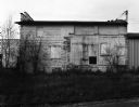
| Description: | View over overgrown railroad tracks toward a small building's wall which is composed of a variety of stone, brick, and wood. |
| Date: | |
|---|---|
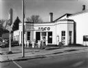
| Description: | View from street of an old brick Ioco gas station with a few cars parked on the left. |
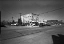
| Date: | |
|---|---|
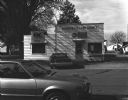
| Description: | View across road of two cars parked near the Orfordville Crop Service. The front wall is adorned with signs for Northrup King Seeds and Borden Smith Dougla... |

| Date: | |
|---|---|
| Description: | Elevated view over a freight train of the Nutrena Feeds factory. |
| Date: | |
|---|---|
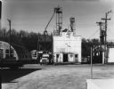
| Description: | View of large building which is depositing feed into a truck docked on its left. On the left there is a Quonset hut-style corrugated metal warehouse, and o... |
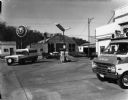
| Date: | |
|---|---|
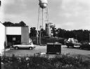
| Description: | View across 76 Service Station parking lot towards a Quonset-hut style corrugated metal building across a street. An ambulance is in the right foreground, ... |

| Date: | |
|---|---|
| Description: | View across small section of road (Huebbe Parkway?) towards a mowed field. A large power or telephone tower rises above a group of trees, and more towers a... |
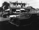
| Date: | |
|---|---|
| Description: | View from parking lot of cars parked in front of Al's Snack Shop. There are awnings over the entrances and two large windows with neon signs. |

| Date: | |
|---|---|
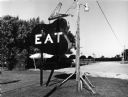
| Description: | A sign prominently displays "OPEN THANKSGIVING DAI" in the top left corner of the frame. Across Third Street behind the sign is the 88 Tavern. Down Portlan... |

| Date: | 11 18 1979 |
|---|---|
| Description: | An electrical box on a wooden pole is in the center foreground. Behind it is a street, and on the other side of the street is a Phillips 66 service station... |

| Date: | 03 24 1980 |
|---|---|
| Description: | A birch tree is in the center foreground. Behind it is a municipal parking lot with an automobile parked in it near the storefront of Neubauer's Sporting G... |
| Date: | 04 1981 |
|---|---|
| Description: | Exterior view from lawn of a white brick bank. Tiny evergreen trees are planted outside and cars are parked alongside the road. |
| Date: | 04 1981 |
|---|---|
| Description: | View across street of parked cars along curb in front of the Suburban Inn, formerly the Park Hotel, on the 300 block of Broom Street. Next door on the righ... |

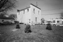
| Date: | 05 1981 |
|---|---|
| Description: | View from across street of house on 2051 Camilla Street. |
If you didn't find the material you searched for, our Library Reference Staff can help.
Call our reference desk at 608-264-6535 or email us at: