 Filter: Categories of Wisconsin Historical Images
Filter: COLLECTION_NAME of Classified File
Filter: Year of 1800-1899
Filter: Subject of landscape
Filter: Categories of Wisconsin Historical Images
Filter: COLLECTION_NAME of Classified File
Filter: Year of 1800-1899
Filter: Subject of landscape

| Date: | 1872 |
|---|---|
| Description: | The sidewheel packet, Red Wing, in the Mississippi River near Queen's Bluff below Trempealeau, Wisconsin. |
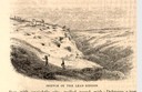
| Date: | 1853 |
|---|---|
| Description: | Engraved view of miners and hillside mines in the Lead Region. Caption reads: "Sketch of the Lead Region." |
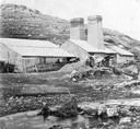
| Date: | 1850 |
|---|---|
| Description: | Blast furnace, also known as a Scotch hearth used in lead mining. |

| Date: | 04 1892 |
|---|---|
| Description: | Drawing of the north shore of Lake Superior with cliffs and seagulls. |

| Date: | 1853 |
|---|---|
| Description: | Engraved image of a boat being towed through a canal at Little Falls by a team of horses. A small town is in the background. |
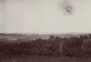
| Date: | 08 1898 |
|---|---|
| Description: | Caption reads: "View from N.E. 1/4 of S.E. 1/4 Sec. 36 L. 12 R 7 W. looking toward Victory, Vernon Co. Wis., showing last 4 miles of trail of Atkinson's Ar... |
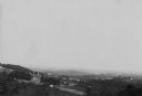
| Date: | 08 1898 |
|---|---|
| Description: | Elevated view along hillsides towards several buildings, forests, and part of a river. Caption reads: "View from N.W. 1/4 of N.W. of Sec. 31. L. 12. R 6 W,... |
If you didn't find the material you searched for, our Library Reference Staff can help.
Call our reference desk at 608-264-6535 or email us at: