 Filter: Categories of Wisconsin Historical Images
Filter: COLLECTION_NAME of Classified File
Filter: Subject of maps
Filter: Categories of Wisconsin Historical Images
Filter: COLLECTION_NAME of Classified File
Filter: Subject of maps
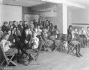
| Date: | 1921 |
|---|---|
| Description: | Classroom full of school children drinking milk at Washington school. |

| Date: | 07 1838 |
|---|---|
| Description: | A map diagram of Indian effigy mounds seven miles east of Blue Mounds in the Wisconsin Territory. |
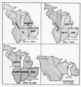
| Date: | 01 11 1805 |
|---|---|
| Description: | Four map illustrations showing the political subdivisions of the Northwest Territory from 1805 through 1834. |
| Date: | 1916 |
|---|---|
| Description: | Kaiser Wilhelm II with Paul von Hindenburg and Erich Ludendorff, commanders on the World War I western front, planning military strategy. |

| Date: | |
|---|---|
| Description: | Looking West from Knight Block, with shipping piers and sailing ships on right side, railroad on left, trees in background. Horse-drawn carriages on street... |

| Date: | 1829 |
|---|---|
| Description: | Map of lead mines operating in Wisconsin. |
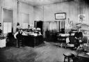
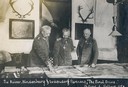
| Date: | 1903 |
|---|---|
| Description: | Superintendent J.N. Harrison and dispatcher W.H. Wright are seated at desks in the Wisconsin & Michigan Railroad office. |

| Date: | 06 1918 |
|---|---|
| Description: | Group of women including Ada James (in checked dress at center) at the suffrage headquarters. A map of Wisconsin is hanging on the wall at right and anothe... |
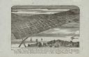
| Date: | 1880 |
|---|---|
| Description: | Bird's-eye map of the city of Madison. Caption reads: "City of Madison — From Park's 'History of Madison, Dane County, and Surrounding Towns.'" The text un... |
If you didn't find the material you searched for, our Library Reference Staff can help.
Call our reference desk at 608-264-6535 or email us at:
