Filter: Categories of Wisconsin Historical Images
Filter: COLLECTION_NAME of Classified File
Filter: Subject of aerial photographs
Filter: Categories of Wisconsin Historical Images
Filter: COLLECTION_NAME of Classified File
Filter: Subject of aerial photographs

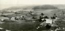
| Date: | 1958 |
|---|---|
| Description: | Aerial view of contour strip farming with the Obert Olstad farm in foreground. The Carl Backum farm is in the background. |

| Date: | 1951 |
|---|---|
| Description: | Aerial view of the Nekoosa-Edwards Paper Company nursery. |
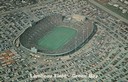
| Date: | 1965 |
|---|---|
| Description: | Aerial view of Lambeau Field, home the Green Bay Packers football team, with a full parking lot. The capacity of the stadium at the time of this photograp... |
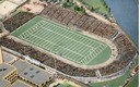
| Date: | |
|---|---|
| Description: | Aerial view of City Stadium, former home of the Green Bay Packers from 1925 to 1956. Currently it is the home of the Green Bay East High School football te... |
| Date: | 08 1948 |
|---|---|
| Description: | Aerial view of the grounds of the Wisconsin Conservation Department exhibit at the Wisconsin Centennial Exposition. |
| Date: | 1948 |
|---|---|
| Description: | Aerial view of the Kimberly-Clark Paper Mill on the Fox River, just east of Appleton. |
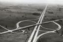
| Date: | 1967 |
|---|---|
| Description: | Intersection of US Highway 41 and Wisconsin Highway 26 near Oshkosh. |

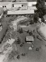
| Date: | 1947 |
|---|---|
| Description: | Aerial view of one hundred ninety government surplus trailers, parked near Camp Randall, provided temporary housing for World War II veterans and their fam... |

| Date: | 1950 |
|---|---|
| Description: | Aerial view of a farm and surrounding fields farmed with the contour method. Shocks of grain dot several of the fields. |
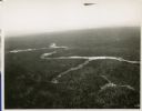
| Date: | 01 1934 |
|---|---|
| Description: | Aerial view of a forest with a river running through it. |

| Date: | 1950 |
|---|---|
| Description: | Aerial view of the Wisconsin State Capitol and Square. |
| Date: | 1930 |
|---|---|
| Description: | Aerial view of two farms, with fields and barns in a valley. This image appeared in Joseph Schafer's 1932 book The Wisconsin Lead Region, on a photo... |
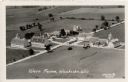
| Date: | 1931 |
|---|---|
| Description: | Aerial view of a farm complex, including a farmhouse and several large buildings. Caption reads: "Wern Farms, Waukesha, Wis." |
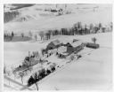
| Date: | 1955 |
|---|---|
| Description: | Aerial view of a farm in winter, with the farmhouse, barn, and outbuildings blanketed in snow. The name Cedar Spring Farm is on the barn. Another farm is i... |
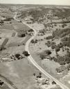
| Date: | |
|---|---|
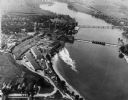
| Description: | Aerial view of a road, with several farms, fields and hills along it. Caption reads: "U.S. 16 near La Crosse, Wis." |

| Date: | |
|---|---|
| Description: | Aerial view of the town of McFarland, with Lake Waubesa in the background. |
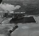
| Date: | 05 12 1959 |
|---|---|
| Description: | Aerial view of a large ship with a considerable amount of dark smoke coming from the rear. The ship appears to be heading toward a large field of coal buil... |
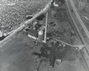
| Date: | 1967 |
|---|---|
| Description: | Aerial view of what is identified by the caption as a "Nuclear power plant near Victory (Vernon Co.), Wis." This would be the La Crosse Boiling Water React... |
If you didn't find the material you searched for, our Library Reference Staff can help.
Call our reference desk at 608-264-6535 or email us at: