 Filter: Categories of Wisconsin Historical Images
Filter: COLLECTION_NAME of Classified File
Filter: Creator Name of Unknown
Filter: Subject of maps
Filter: Categories of Wisconsin Historical Images
Filter: COLLECTION_NAME of Classified File
Filter: Creator Name of Unknown
Filter: Subject of maps

| Date: | 07 1838 |
|---|---|
| Description: | A map diagram of Indian effigy mounds seven miles east of Blue Mounds in the Wisconsin Territory. |
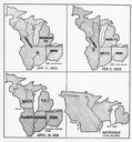
| Date: | 01 11 1805 |
|---|---|
| Description: | Four map illustrations showing the political subdivisions of the Northwest Territory from 1805 through 1834. |

| Date: | 06 1918 |
|---|---|
| Description: | Group of women including Ada James (in checked dress at center) at the suffrage headquarters. A map of Wisconsin is hanging on the wall at right and anothe... |
If you didn't find the material you searched for, our Library Reference Staff can help.
Call our reference desk at 608-264-6535 or email us at:
