Filter: Categories of Wisconsin Historical Images
Filter: COLLECTION_NAME of Albertype Company photographs, circa 1880s-circa 1950
Filter: Subject of landforms
Filter: Categories of Wisconsin Historical Images
Filter: COLLECTION_NAME of Albertype Company photographs, circa 1880s-circa 1950
Filter: Subject of landforms
| Date: | |
|---|---|
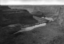
| Description: | Elevated view down the Snake River Canyon toward the Blue Lakes, near Twin Falls. The canyon is formed by the Snake River in the Magic Valley region of sou... |
| Date: | |
|---|---|
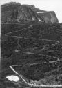
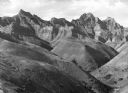
| Description: | Elevated view of a donkey train going up a zig-zag trail along the mountainside in Glacier National Park. |

| Date: | |
|---|---|
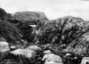
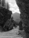
| Description: | Elevated view of Winona Falls Gorge spanned by a small wooden bridge. Someone is resting in the middle of the bridge and a dense stand of pine trees surrou... |
| Date: | |
|---|---|
| Description: | View of a gorge on Mystic Lake with forest covered mountains in the distance. |

| Date: | |
|---|---|
| Description: | View across valley toward Mesa Encantada, a large stone formation. Caption reads: Mesa Encantada, N. Mex." |
| Date: | |
|---|---|
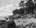
| Description: | View toward children playing on a beach among large rocks, with beach houses and trees in the background. |
| Date: | |
|---|---|
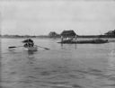
| Description: | View across water toward the shore. People are rowing a boat in the foreground, and people are standing on a rock near the shore. In the background are hou... |
| Date: | |
|---|---|
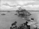
| Description: | Elevated view from Hubinger's Island featuring other islands, homes, and a boat. |
| Date: | 1930 |
|---|---|
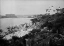
| Description: | View along top of rocky cliff toward a home on the right overlooking the ocean, with a large building further down the curving shoreline in the distance. |
| Date: | 1925 |
|---|---|
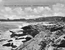
| Description: | View along rocky coastline with crashing waves. Buildings are along the shoreline in the distance. Caption reads: "View from Ye Headland Inn. Trefethen, Ma... |
| Date: | |
|---|---|
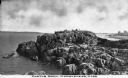
| Description: | Elevated view of Castle Rock, located on the coast, with numerous people looking out over the water. Caption reads: "Castle Rock, Marblehead, Mass." |

| Date: | |
|---|---|
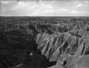
| Description: | Elevated view of the painted Badlands reaching out to the horizon. |
| Date: | |
|---|---|
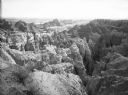
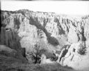
| Description: | Elevated view of the rocky outcroppings of the Badlands landscape. |
| Date: | |
|---|---|
| Description: | View of a landscape in the Badlands, including a small shrub in the foreground. |
| Date: | |
|---|---|
| Description: | A view of the Badlands landscape. Rolling formations in the foreground give way to more extreme ones in the background. |

| Date: | |
|---|---|
| Description: | Hand-drawn map of the area at the time of Pilgrim landing, drawn by Charles Blaskowikz. Includes commemorative historical notes. |

| Date: | |
|---|---|
| Description: | Four men stand around a sulphur bin with a massive cliff behind it at Freeport Sulphur Company, founded in 1912. |

| Date: | |
|---|---|
| Description: | View of the Salt Creek Oil Field. In the 1920's, one-fifth of all petroleum produced in the United States came from one oil field. |
If you didn't find the material you searched for, our Library Reference Staff can help.
Call our reference desk at 608-264-6535 or email us at: