Property Record
N3054 STH 67
Architecture and History Inventory
| Historic Name: | Frank M. Hicks House |
|---|---|
| Other Name: | |
| Contributing: | |
| Reference Number: | 9820 |
| Location (Address): | N3054 STH 67 |
|---|---|
| County: | Walworth |
| City: | |
| Township/Village: | Geneva |
| Unincorporated Community: | |
| Town: | 2 |
| Range: | 17 |
| Direction: | E |
| Section: | 30 |
| Quarter Section: | SW |
| Quarter/Quarter Section: | NW |
| Year Built: | 1891 |
|---|---|
| Additions: | |
| Survey Date: | 2011 |
| Historic Use: | house |
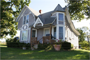
| Architectural Style: | Queen Anne |
| Structural System: | |
| Wall Material: | Clapboard |
| Architect: | |
| Other Buildings On Site: | |
| Demolished?: | No |
| Demolished Date: |
| National/State Register Listing Name: | Not listed |
|---|---|
| National Register Listing Date: | |
| State Register Listing Date: |
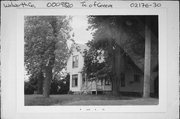
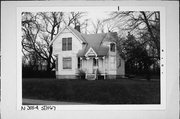
| Additional Information: | Initially surveyed in 1994 - BARGE BOARDS IN GABLE CARVED ORNAMENTAL PANELS OBSCURED BY VEG RE-SURVEYED 2011 - The earliest available historic atlas showing land ownership (1873) indicates James Aram, a farmer, as the owner of the property. While a building is indicated at this time, it is likely not the Queen Anne house that exists today. The first available map showing acreage for the property is 1891; Frank M. Hicks is listed as the owner of the property, which at that time included 60 acres. Frank M. Hicks, also a farmer, more than likely played a role in the construction of the present house. The next available map, dated 1921, indicates the property under the ownership of Harold Williams. Harold Williams remained the owner of the property until 1976, when he died. |
|---|---|
| Bibliographic References: | 1873 Combination Atlas Map of Walworth County, Wisconsin; 1891 Plat Map of Walworth County, Wisconsin; 1921 Standard Atlas of Walworth County, Wisconsin; 1930 Plat Book of Walworth County, Wisconsin; 1948 Farm Plat Book and Business Guide Walworth County, Wisconsin; 1952 and 1959 Official County Plat Book and Rural Directory of Walworth County, Wisconsin; 1955 Plat Book and Farmer's Directory Walworth County, Wisconsin; 1961 Plat Book with Farm Directory Walworth County, Wisconsin; 1961, 1971, 1980, 1990, 2008 Land Atlas and Plat Book of Walworth County, Wisconsin; and Census Records, accessed at www.ancestry.com Architecture and History Survey, 12-0123/WL. September 2011. Rachel E. Bankowitz. |
| Wisconsin Architecture and History Inventory, State Historic Preservation Office, Wisconsin Historical Society, Madison, Wisconsin |


