Property Record
S5244 US HIGHWAY 12
Architecture and History Inventory
| Historic Name: | William and Elizabeth Toole House |
|---|---|
| Other Name: | |
| Contributing: | |
| Reference Number: | 40823 |
| Location (Address): | S5244 US HIGHWAY 12 |
|---|---|
| County: | Sauk |
| City: | |
| Township/Village: | Baraboo |
| Unincorporated Community: | |
| Town: | 11 |
| Range: | 6 |
| Direction: | E |
| Section: | 3 |
| Quarter Section: | SE |
| Quarter/Quarter Section: | SW |
| Year Built: | 1875 |
|---|---|
| Additions: | |
| Survey Date: | 19952015 |
| Historic Use: | house |
| Architectural Style: | Greek Revival |
| Structural System: | Balloon Frame |
| Wall Material: | Clapboard |
| Architect: | |
| Other Buildings On Site: | |
| Demolished?: | No |
| Demolished Date: |
| National/State Register Listing Name: | Not listed |
|---|---|
| National Register Listing Date: | |
| State Register Listing Date: |
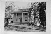
| Additional Information: | A 'site file' exists for this property. It contains additional information such as correspondence, newspaper clippings, or historical information. It is a public record and may be viewed in person at the Wisconsin Historical Society, Division of Historic Preservation. This is a two-story Greek Revival house with clapboard siding, and was probably built for John Williams in the 1870s. The windows are wood 2/2 dhs. The side-gabled roof is surfaced with asphalt shingles. There is a two-story cutaway porch with plain posts across the front facade. In 1884, William Toole bought the property. Here he developed a national reputation for growing and breeding pansies. As a result, the property came to be known as Pansy Heights. Toole is also significant as a co-founder and leader of the Country Life Association, a national network of education clubs for rural children that was similar to, yet preceded, the 4-H. |
|---|---|
| Bibliographic References: | Alden Publishing Company. Atlas of Sauk County. 1906. Canfield, William. Map of Sauk County. 1859; 1861. Butterfield, C. W. The History of Sauk County, Wisconsin. Chicago: Western Historical Company, 1880. Ogle, George A. Atlas of Sauk County. 1922. Smith, Maurice W. Plat Map of Sauk County. 1893. Tucker, M. G. Plat Map of Sauk County. 1877. |
| Wisconsin Architecture and History Inventory, State Historic Preservation Office, Wisconsin Historical Society, Madison, Wisconsin |

