Property Record
2351 N Biron Drive
Architecture and History Inventory
| Historic Name: | |
|---|---|
| Other Name: | |
| Contributing: | |
| Reference Number: | 246392 |
| Location (Address): | 2351 N Biron Drive |
|---|---|
| County: | Wood |
| City: | Biron |
| Township/Village: | |
| Unincorporated Community: | |
| Town: | 23 |
| Range: | 6 |
| Direction: | E |
| Section: | 26 |
| Quarter Section: | SE |
| Quarter/Quarter Section: | SE |
| Year Built: | 1966 |
|---|---|
| Additions: | |
| Survey Date: | 2023 |
| Historic Use: | house |
| Architectural Style: | Other Vernacular |
| Structural System: | |
| Wall Material: | Aluminum/Vinyl Siding |
| Architect: | |
| Other Buildings On Site: | N |
| Demolished?: | No |
| Demolished Date: |
| National/State Register Listing Name: | Not listed |
|---|---|
| National Register Listing Date: | |
| State Register Listing Date: |
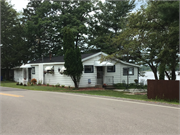
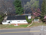
| Additional Information: | This small, one-story front-gable house is set on the north side N. Biron Drive on the southern bank of the Wisconsin River. Assessor records did not include a date of construction, but aerial photographs indicate it was built between 1966 and 1968. Given its small size, minimal ornamentation, and proximity to the water, this house was likely constructed as a seasonal cabin. The house has a concrete foundation and walls clad in wide synthetic lap siding. Fascia runs along the perimeter of the asphalt shingled roof. The sliding and casement windows appear to be aluminum frames. The entrances and two windows on the south and east elevations are surmounted by vinyl awnings. A shed-roof addition runs the length of the house’s north elevation, giving the house the appearance of a saltbox roof. |
|---|---|
| Bibliographic References: | Wood Co Assessor Historicaerials.com Marathon Map Service, 1948. Rudolph Township, Standard Atlas of Wood County. https://historicmapworks.com/Map/US/156241/Rudolph+Township/Wood+County+1948/Wisconsin/ Marathon Atlas Publishers, 1957. Rudolph Township, Biron, Wisconsin River, Standard Atlas of Wood County. https://historicmapworks.com/Map/US/64504/Rudolph+Township++Biron++Wisconsin+River/Wood+County+1957/Wisconsin/ Ogle, Geo. A. & Co., 1909. Grand Rapids Township, Standard Atlas of Wood County. https://search.library.wisc.edu/digital/AHOYNBBET73VWL8U Ogle, Geo. A. & Co., 1928. Grand Rapids Township, Standard Atlas of Wood County. https://search.library.wisc.edu/digital/AW6DDKNMD3TGQW8V |
| Wisconsin Architecture and History Inventory, State Historic Preservation Office, Wisconsin Historical Society, Madison, Wisconsin |


