Property Record
801 Werner Allen Blvd
Architecture and History Inventory
| Historic Name: | W.H. Hatten Recreation Park Stone Perimeter Wall |
|---|---|
| Other Name: | |
| Contributing: | |
| Reference Number: | 245648 |
| Location (Address): | 801 Werner Allen Blvd |
|---|---|
| County: | Waupaca |
| City: | New London |
| Township/Village: | |
| Unincorporated Community: | |
| Town: | |
| Range: | |
| Direction: | |
| Section: | |
| Quarter Section: | |
| Quarter/Quarter Section: |
| Year Built: | 1936 |
|---|---|
| Additions: | |
| Survey Date: | 2023 |
| Historic Use: | wall |
| Architectural Style: | |
| Structural System: | |
| Wall Material: | |
| Architect: | |
| Other Buildings On Site: | Y |
| Demolished?: | No |
| Demolished Date: |
| National/State Register Listing Name: | Not listed |
|---|---|
| National Register Listing Date: | |
| State Register Listing Date: |
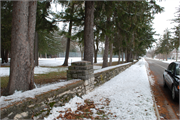
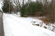
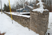
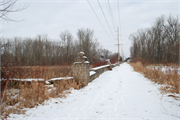
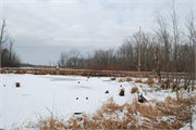
| Additional Information: | The Perimeter Walls are random, rock-faced, limestone ashlar walls with intermittent random, rock-faced, limestone ashlar piers, topped with a concrete cap. The walls form the east, west, and south boundaries of the park. The east wall is 600 feet long from the Washington Street Entrance to the northeast corner of the park, and 2010 feet from the Washington Street Entrance to the southeast corner of the park. The south wall measures 380 feet from the southeast corner of the park to the Jennings Street Entrance, and 885 feet from the Jennings Street Entrance to the southwest corner of the park. The east and south walls are three feet tall; a small section that was built through the creek at the west edge of the park has collapsed into the water. The west wall varies in height from three to four feet through the five sections that make up its length and follow the park boundary along the west line of Section 13, westward into the northeast ¼ of Section 14 and back eastward to the west line of Section 13, and then following the property line along the west line of Section 13 north to West Wolf River Avenue. The total length of the Perimeter Walls is 13,563 feet and there are 104 stone piers. |
|---|---|
| Bibliographic References: |
| Wisconsin Architecture and History Inventory, State Historic Preservation Office, Wisconsin Historical Society, Madison, Wisconsin |

