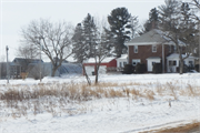
| Additional Information: | This farmstead stands on the south side of County Road S in the northeast quarter of Emerald Township. Current aerial photos show that the property consists of the historic farmhouse, shed-roof barn, Quonset Hut, small animal barn, and large machine shed, as well as two non-historic metal outbuildings. The house is set at the northwest corner, the main barn is along the east side, and the remaining buildings are along the south side of the farm. The house and barn were constructed sometime before the 1939 aerial photograph. The Quonset Hut, large machine shed, and small animal barn were added sometime after World War II. The non-historic machine shed was built sometime before 1992, while the garage just south of the house was built ca 2011. Photographs indicate the composition of buildings has changed several times since 1939; several smaller farm buildings have been demolished, some of which have been replaced. The farmstead has a tree windbreak along its western and part of its northern boundaries, the dense vegetation obscures views from the west and northwest.
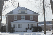
The house is a 2.5-story brick foursquare. It exhibits elements of the Prairie style, with a prominent low-pitched, flat-top pyramidal roof. It stands on a concrete block foundation and has a brick tile belt course around the base of the house. The walls are clad in red brick, with brick tile sills and soldier-course brick lintels at the windows. A small hipped-roof window bay projects from each side of the first floor; they have projecting brick supports. The window bays and a front-facing hipped-roof dormer and are clad in vinyl lap siding. The hipped-roof porch spans nearly the entire width of the façade. It is likely original, but its integrity of design and materials was affected with the porch was enclosed and clad with vinyl siding. A one-story entry bay is set at the back of the house.
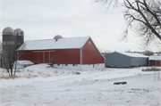
The historic-age barn is set on the east side of the farmstead. The bank barn has a saltbox roof that extends to the basement level in the rear. The raised concrete block base has glass block windows. An earthen embankment and wood landing leads to a large pair of sliding doors in the north façade. A small gabled addition is set at the northeast corner next to the embankment. The barn has a small window in the gable end, and a weathervane and several lightning rods on the roof. Three silos are set on the east side of the barn. Its roof has asphalt shingles, and the walls are clad in vertical metal panels. The walls and doors are modern replacements.
A modern two-stall garage with gabled roof and metal walls is set immediately south of the house; it was built ca 2011. Further south along the west side of the farmstead is a post-World War II Quonset hut. Most views are obscured, but it has a large sliding door across its east end wall. A gabled structure stands south of the Quonset hut; it appears to be the framework of a structure with a gabled roof and used for storage.
Three buildings are set along the south side of the property. The first is a small animal barn that has a concrete block base and metal-clad walls. Its windows are covered over, and the gable roof is showing signs of structural compromise. The second is a small, non-historic machine shed with a side-gable roof and sliding doors. The third is a large, historic-age machine shed. Its lumber base is exposed, and it has corrugated metal walls and roofing. It is showing signs of disrepair and is in fair condition.
The 1876 plat map shows that the northwest quadrant of Section 3 in Emerald Township was owned by the North Wisconsin Railroad Company. By 1897, it had been homesteaded by Cath. Salmon and in 1914 it was owned by P.L. Salmon.
The center point coordinates of the farmstead is -92.304, 45.15 |
|---|
| Bibliographic References: | Briggs, S.W.
1876 “Map of Saint Croix County, Wisconsin, 1876.” Milwaukee: J. Knauber & Co. Lithographers. Online resource, digitized by WHS, https://content.wisconsinhistory.org/digital/collection/maps/id/1484/, accessed February 2022.
National Park Service
Nd “History and Culture” Saint Croix National Scenic Riverway, WI, MN. Online resource, https://www.nps.gov/sacn/learn/historyculture/index.htm, accessed February 2022.
Pinkney & Brown
1897 Atlas and Farmers Directory of St. Croix County, Wisconsin. St. Paul: The Farmer Journal of Agriculture. Online resource, digitized by Historic Mapworks, http://www.historicmapworks.com/Atlas/US/16630, accessed February 2022.
St. Croix County
2006 “2006 Heartland Comprehensive Plan.” Prepared by the St. Croix County Planning & Zoning Department and University of Wisconsin-Extension. Online resource, https://www.sccwi.gov/DocumentCenter/View/644/2006-Heartland-Comprehensive-Plan-Adopted-PDF, accessed February 2022.
Snyder, Van Vechten & Co.
1878 “Map of St. Croix County.” Milwaukee: Snyder, Van Vechten & Co. Online resource, digitized by David Rumsey Map Collection, http://www.davidrumsey.com/maps4104.html, accessed February 2022.
Webb Publishing Co.
1914 Atlas and Farmers Directory of St. Croix County, Wisconsin. St. Paul: The Farmer Journal of Agriculture. Online resource, digitized by Historic Mapworks, http://www.historicmapworks.com/Atlas/US/16631/, accessed February 2022.
|
|---|


