Property Record
1699 Maloney Road
Architecture and History Inventory
| Historic Name: | |
|---|---|
| Other Name: | |
| Contributing: | |
| Reference Number: | 242858 |
| Location (Address): | 1699 Maloney Road |
|---|---|
| County: | Outagamie |
| City: | Kaukauna |
| Township/Village: | |
| Unincorporated Community: | |
| Town: | 21 |
| Range: | 18 |
| Direction: | E |
| Section: | 12 |
| Quarter Section: | SE |
| Quarter/Quarter Section: | SW |
| Year Built: | 1945 |
|---|---|
| Additions: | |
| Survey Date: | 2020 |
| Historic Use: | barn |
| Architectural Style: | Astylistic Utilitarian Building |
| Structural System: | Timber Frame |
| Wall Material: | Board and Batten |
| Architect: | |
| Other Buildings On Site: | Y |
| Demolished?: | No |
| Demolished Date: |
| National/State Register Listing Name: | Not listed |
|---|---|
| National Register Listing Date: | |
| State Register Listing Date: |
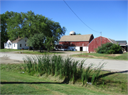
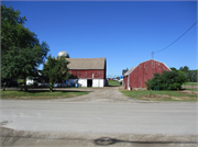
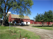
| Additional Information: | 2020 - This two-story astylistic basement barn was constructed ca. 1945 (sometime between 1938 and 1951 based on aerials). It occupies an irregular footprint and terminates in a gambrel roof that is sheathed in asphalt shingles. A one-story gambrel-roof unit extends out from the southern end of the barn’s east elevation, and features a shed-roof addition on its north elevation. A one-story gambrel-roof unit also projects out from the northern end of the barn’s west elevation. The barn features a concrete-block first story and a second story clad in board and batten. Windows include four-light wood units on the barn’s first story and on the one-story units that project out on the east and west elevations. A replacement fixed single window is located on the barn’s east elevation. The resource is in fair physical condition. Alterations include the construction of a small shed roof addition on the east elevation of the barn within the past ca. 50 years and installation of replacement asphalt shingles and a fixed single window on the east elevation within the past ca. 40 years. The barn forms part of a farmstead that consists of a ca. 1945 silo approximately 8 feet to the west (AHI Number 242915); a ca. 1945 front-gable former garage that currently appears to be used for storage approximately 9 feet to the south (AHI Number 242916); a ca. 1945 farmhouse approximately 42 feet to the southeast (AHI Number 242857); a small ca. 1960 barn approximately 15 feet to the north (AHI Number 242917); a ca. 1960 former garage that appears to have been converted to storage use approximately 15 feet to the north (AHI Number 242918); and a ca. 1995 storage building approximately 22 feet northwest of the house. An agricultural field is in the western half of the parcel occupied by the subject farmstead. |
|---|---|
| Bibliographic References: | Jacobs Engineering Group, Inc. 2021. Architectural History Survey Report for the Proposed I-41 Project, Brown and Outagamie Counties, Wisconsin. WisDOT Project ID 1130-63-00. |
| Wisconsin Architecture and History Inventory, State Historic Preservation Office, Wisconsin Historical Society, Madison, Wisconsin |


