Property Record
416 EBENEZER ROAD
Architecture and History Inventory
| Historic Name: | |
|---|---|
| Other Name: | |
| Contributing: | |
| Reference Number: | 242816 |
| Location (Address): | 416 EBENEZER ROAD |
|---|---|
| County: | Grant |
| City: | |
| Township/Village: | Wingville |
| Unincorporated Community: | |
| Town: | 6 |
| Range: | 1 |
| Direction: | W |
| Section: | 35 |
| Quarter Section: | SE |
| Quarter/Quarter Section: | NE |
| Year Built: | 1955 |
|---|---|
| Additions: | |
| Survey Date: | 20202021 |
| Historic Use: | house |
| Architectural Style: | |
| Structural System: | |
| Wall Material: | Aluminum/Vinyl Siding |
| Architect: | |
| Other Buildings On Site: | Y |
| Demolished?: | No |
| Demolished Date: |
| National/State Register Listing Name: | Not listed |
|---|---|
| National Register Listing Date: | |
| State Register Listing Date: |
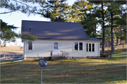
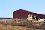
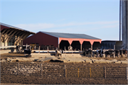
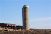
| Additional Information: | 01/2021: The property includes a ca. 1955 Minimal Traditional style dwelling (a), a ca. 1975 hay barn (b), a ca. 1950 livestock barn (c), a ca. 1950 silo (d), a ca. 1955 banked shed (e), and a non-historic-age grain bin. The one-and-a-half-story, side-gabled dwelling features a replacement standing-seam metal roof and replacement vinyl siding and windows. The front entrance includes a single door with a small stoop, concrete steps, and an iron railing. A small one-story, gabled vestibule addition and uncovered deck are located on the eastern side elevation. Together the additions and alterations obscure the resource’s original form and architectural detailing if present historically. The hay barn (b) is located northwest of the dwelling. The large side-gabled, metal-clad barn features a tall, operable overhead garage door on the southern side elevation. Nine bays of hay lofts are exposed below a shed roof on the eastern façade. The livestock barn (c) is north of the hay barn (b). The livestock barn is of pole construction and features a metal roof, metal paneled siding, and four open bays on the primary southeastern façade. No other discernable details of the livestock barn (c) were visible from the public ROW. The concrete stave silo (d) located east of the livestock barn (c) includes an aluminum-clad roof. The banked shed (e) is located east of the dwelling and is integrated into the sloping terrain of the property. The shed features a front-gabled asphalt shingle roof and exposed rafters and is of concrete masonry unit construction with vinyl siding in the gable ends. A pair of hinged wooden doors punctuates the primary façade. According to historic aerial imagery, the livestock barn (c) and silo (d) were constructed by 1951. The dwelling (a) and banked shed (e) appear on site by 1955. The hay barn (b) is visible on the 1982 aerial (NETR 2020). The resources (a-e) do not appear on the earlier 1902 Mineral Point quadrangle map (USGS 1902) or 1918 Grant County Plat Map (Geo. A. Ogle & Company 1918). 12/2021: The farmstead remains in the same condition as during its 2020 survey. This farmstead stands on the north side of Ebenezer Road 0.3 miles west of Stockyard Road. It was previously surveyed in 2020. Aerial photographs show this farmstead has been present since at least 1940, but few resources from that period are extant. The original farmhouse was replaced with the current house ca 1955. The small, single-story minimal traditional style house has been altered with replacement vinyl siding, metal roof, and doors and windows. The original barn is nonextant. A ca 1950 livestock barn is of pole construction; it has a metal roof and siding and four exposed bays across its east elevation. The ca 1975 livestock barn has a frame structure and metal walls and roof. A small ca 1955 shed is banked into hillside; it has concrete walls, gabled roof with exposed rafter tails, and a pair of doors in the end wall. |
|---|---|
| Bibliographic References: | Grant County GIS Services 2020 Grant County Parcel Viewer. Electronic document, https://gis.co.grant.wi.gov/Parcel_Explorer/, accessed October 6, 2020. Geo. A. Ogle & Company 1918 Standard Atlas of Grant County Wisconsin. Electronic document, http://www.historicmapworks.com/Map/US/29123/Title+Page/Grant+County+1918/Wisconsin/, accessed January 13, 2021. Nationwide Environmental Title Research (NETR) 2020 Historic Aerials Viewer. Electronic document, https://www.historicaerials.com/viewer, accessed October 6, 2020. U. S. Geological Survey (USGS) 1902 Mineral Point 1: 125, 000 Topographic Quadrangle Map. Reston, VA. 1952 Montfort 1: 24, 000 Topographic Quadrangle Map. Reston, VA. Wisconsin Historical Society (WHS) 1986 Cultural Resource Management in Wisconsin: A Manual for Historic Properties, Volumes 1-3. Historic Preservation Division. State Historical Society of Wisconsin. Copy provided by the Wisconsin Historical Society. |
| Wisconsin Architecture and History Inventory, State Historic Preservation Office, Wisconsin Historical Society, Madison, Wisconsin |


