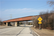
Property Record
SOUTH OF INTERSECTION OF N TEUTONIA AVE & STH 57/N GREEN BAY RD
Architecture and History Inventory
| Historic Name: | Chicago, Milwaukee, St. Paul & Pacific Railroad Bridge |
|---|---|
| Other Name: | |
| Contributing: | |
| Reference Number: | 234430 |
| Location (Address): | SOUTH OF INTERSECTION OF N TEUTONIA AVE & STH 57/N GREEN BAY RD |
|---|---|
| County: | Milwaukee |
| City: | Brown Deer |
| Township/Village: | |
| Unincorporated Community: | |
| Town: | |
| Range: | |
| Direction: | |
| Section: | |
| Quarter Section: | |
| Quarter/Quarter Section: |
| Year Built: | 1962 |
|---|---|
| Additions: | |
| Survey Date: | 20182024 |
| Historic Use: | bridge |
| Architectural Style: | NA (unknown or not a building) |
| Structural System: | |
| Wall Material: | Metal |
| Architect: | |
| Other Buildings On Site: | |
| Demolished?: | No |
| Demolished Date: |
| National/State Register Listing Name: | Not listed |
|---|---|
| National Register Listing Date: | |
| State Register Listing Date: |
| Additional Information: | The railroad line on which this bridge was built is the historic Wisconsin Central Railroad route that extended from Milwaukee to Germantown and points north. The line would later be run by the Chicago, Milwaukee & St. Paul Railroad and, by the time of the bridge’s circa-1962 construction, it was known as the Chicago, Milwaukee, St. Paul & Pacific Railroad. Prior to the bridge’s construction, at-grade tracks ran across the roadway. 2024: appearance unchanged. steel beam or plate girder bridge |
|---|---|
| Bibliographic References: | State Highway Commission of Wisconsin, General Plan, Structure B-40-157/Chicago, Milwaukee, St. Paul and Pacific Railroad, Bridge No. U-18, dated 19 June 1961; corrected and approved, January 1962, Copy of bridge plans on file at Heritage Research, Ltd., Menomonee Falls, WI. A comparison of aerial images available online confirm the existence of the previous at-grade crossing, Historic aerials (1928 to current; various dates available), Included in the Milwaukee County Land Records GIS mapping, Available online at http://gcswebportal.milwaukeecounty.org/GCSWebPortal/Search.aspx., Accessed February 2018. |
| Wisconsin Architecture and History Inventory, State Historic Preservation Office, Wisconsin Historical Society, Madison, Wisconsin |


