Property Record
ROOT RIVER AT LINCOLN PARK
Architecture and History Inventory
| Historic Name: | Root River Retaining Wall |
|---|---|
| Other Name: | Root River retaining Wall |
| Contributing: | |
| Reference Number: | 122527 |
| Location (Address): | ROOT RIVER AT LINCOLN PARK |
|---|---|
| County: | Racine |
| City: | Racine |
| Township/Village: | |
| Unincorporated Community: | |
| Town: | |
| Range: | |
| Direction: | |
| Section: | |
| Quarter Section: | |
| Quarter/Quarter Section: |
| Year Built: | 1941 |
|---|---|
| Additions: | |
| Survey Date: | 2002 |
| Historic Use: | fence/wall |
| Architectural Style: | NA (unknown or not a building) |
| Structural System: | Stone |
| Wall Material: | Fieldstone |
| Architect: | J. Schroeder/Works Progress Administration |
| Other Buildings On Site: | |
| Demolished?: | No |
| Demolished Date: |
| National/State Register Listing Name: | Not listed |
|---|---|
| National Register Listing Date: | |
| State Register Listing Date: |
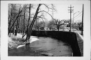
| Additional Information: | Situated on the "current" side of a gentle bend in the Root River, this fieldstone retaining wall is approximately 700 feet long and twelve feet high. It is topped with a concrete cap. Plans indicate that the base is approximately three feet below the bottom of the river and is four feet wide. The visible portion of the wall is tapered and has a width of eighteen inches at the top. Metal drainpipes are fitted every ten feet and are situated slightly above the mean low water level. A modern, steel, pedestrian bridge crosses the river near the wall's western end. Situated on the other side of the river is Lincoln Park, which consists of several athletic fields and parking lots as well as a fish weir, playground equipment, and a road. All these resources appear to date to the 1970s. A pair of ca. 1960s picnic pavilions are also evident. Built in 1941, this retaining wall was designed by J. Schroeder and sponsored by the Works Progress Administration at a cost of $11,496. It appears to have been built to provide a stable river embankment, which allowed for Spring Street to run adjacent to the river at this location. According to these plans, the river's original, unimproved, embankment was within a few feet of the street. No evidence was found to suggest that the retaining wall was part of any master erosion- or floor-control plan for the Root River. |
|---|---|
| Bibliographic References: | Architecture and History Survey. January 2002. Prepared by Heritage Research, Ltd. |
| Wisconsin Architecture and History Inventory, State Historic Preservation Office, Wisconsin Historical Society, Madison, Wisconsin |

