Property Record
STATE HIGHWAY 88 AND ELK CREEK
Architecture and History Inventory
| Historic Name: | Rainbow Lake Park |
|---|---|
| Other Name: | Rainbow Lake Park |
| Contributing: | |
| Reference Number: | 122045 |
| Location (Address): | STATE HIGHWAY 88 AND ELK CREEK |
|---|---|
| County: | Buffalo |
| City: | |
| Township/Village: | Gilmanton |
| Unincorporated Community: | |
| Town: | 23 |
| Range: | 11 |
| Direction: | W |
| Section: | 14 |
| Quarter Section: | |
| Quarter/Quarter Section: |
| Year Built: | |
|---|---|
| Additions: | |
| Survey Date: | 20012017 |
| Historic Use: | park |
| Architectural Style: | NA (unknown or not a building) |
| Structural System: | |
| Wall Material: | |
| Architect: | |
| Other Buildings On Site: | |
| Demolished?: | No |
| Demolished Date: |
| National/State Register Listing Name: | Not listed |
|---|---|
| National Register Listing Date: | |
| State Register Listing Date: |
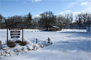
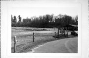
| Additional Information: | April 2001-Rainbow Lake Park features a pond stocked with fish, a shelter and rest rooms. It is located east of STH 88 on the site of the former millpond. Flood waters, which caused damage to the dam on a regular basis, eventually forced the mill to convert to electrical power. The dam was not replaced after it failed during a severe flood and the pond area was left vacant for years until the Sportsmen#25;s Club was encouraged by the community at large to undertake the construction of a recreational facility featuring a smaller pond and a park for community use. Rainbow Lake Park was established in the mid-1970s. 2017- "Rainbow Lake Park is located on the east side of STH 88 at the south end of the unincorporated community of Gilmanton. Located on the site of a former millpond, the park comprises a small pond, parking area, and recreational facilities. Structures consist of a c.1975, gable-roof, open-air picnic shelter, small gable roof restroom building, and several playground structures. Modern wood fishing piers extend from the shoreline north and east of the picnic shelter, and a wood sign is located on the north side of the driveway leading from STH 88." -"STH 88: CTH U to STH 37", WisDOT#7730-02-30, Prepared by Mead & Hunt, Inc., (2017). |
|---|---|
| Bibliographic References: | Amidon, 1986: 74-75. |
| Wisconsin Architecture and History Inventory, State Historic Preservation Office, Wisconsin Historical Society, Madison, Wisconsin |


