Property Record
E. Mason St. over Lincoln Memorial Dr.
Architecture and History Inventory
| Historic Name: | Mason Street Bridge (B-40-524) |
|---|---|
| Other Name: | Lincoln Memorial Drive Bridge |
| Contributing: | |
| Reference Number: | 117745 |
| Location (Address): | E. Mason St. over Lincoln Memorial Dr. |
|---|---|
| County: | Milwaukee |
| City: | Milwaukee |
| Township/Village: | |
| Unincorporated Community: | |
| Town: | |
| Range: | |
| Direction: | |
| Section: | |
| Quarter Section: | |
| Quarter/Quarter Section: |
| Year Built: | 1982 |
|---|---|
| Additions: | |
| Survey Date: | 19842023 |
| Historic Use: | bridge |
| Architectural Style: | NA (unknown or not a building) |
| Structural System: | Reinforced Concrete |
| Wall Material: | Concrete |
| Architect: | Wisconsin Department of Transportation; Lunda Construction, general contractors |
| Other Buildings On Site: | |
| Demolished?: | No |
| Demolished Date: |
| National/State Register Listing Name: | Not listed |
|---|---|
| National Register Listing Date: | |
| State Register Listing Date: |
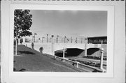
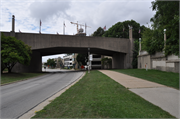
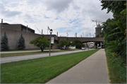
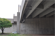
| Additional Information: | Surveyed in 2023 as part of the Mason St. Bridge rehabilitation project. The Mason Street Bridge structure was built in 1982 and consists of two portions: a prestressed concrete deck girder bridge that carries Mason Street over Lincoln Memorial Drive, and an adjacent ramp from Mason Street down to Lincoln Memorial Drive. An interior parking garage is located within the ramp structure and is accessed from the lakefront-level parking lot north of the War Memorial. The bridge is approximately 675 feet in length and carries a 4-lane, 50-foot-wide roadway with 13-foot-wide sidewalks on either side. It has full retaining wall abutments and two cast-in-place concrete piers. The bridge has solid parapet walls with concrete cladding panels. In a nod to the Beaux Arts style of the previous bridge on this site, the parapets are lined with paired concrete columns topped with lights. The ramp structure contains a large public plaza at the level of Mason Street. The plaza contains commemorative statuary and flagpoles associated with the adjacent War Memorial. The north portion of the ramp structure contains the roadway, with similar dimensions and cladding materials as the bridge portion. The parapets of the ramp are lined with paired columns as well. Beneath the roadway, a large interior parking garage located within the structure of the ramp provides storage space for service vehicles. The Mason Street Bridge was designed to replace an older structure built in 1926 as part of the development of the lakefront Lincoln Memorial Drive. In the 19th century, Milwaukee’s lakefront was lined with railroad tracks and was prone to erosion and flooding. In the 1920s, the city’s Socialist leaders began an ambitious landfill project to create an artificial shoreline with public beaches, parks, and a scenic roadway known as Lincoln Memorial Drive. Architect Alfred Clas designed a Beaux- Arts style bridge and plaza to link the lakefront drive to the existing city streets, located at the top of the bluff. The Lincoln Memorial Bridge opened in 1926, and the entire Lincoln Memorial Drive was completed in 1929. In the early 1950s, after decades of planning and debate, Milwaukee County selected the eastern terminus of Mason Street as the location for its new War Memorial. This new building was constructed on the eastern edge of the existing ramp structure, and the 1926 Beaux-Arts plaza served as a forecourt for Eero Saarinen’s dramatic postwar building. By the 1970s, the Lincoln Memorial Bridge was in a bad state of repair. It was closed to traffic several times while politicians and city leaders debated whether to replace the bridge, build a pedestrian mall over it, or turn the bridge and lakefront drive into part of an envisioned freeway system. In the end, Lincoln Memorial Drive remained a scenic lakefront roadway, and in 1981, the former Lincoln Memorial Bridge was razed and replaced with the existing Mason Street Bridge. As part of the reconstruction, the historic plaza was also reshaped from its original curvilinear footprint to its current rectangular layout. This prestressed concrete deck girder bridge was the first use of cantilevered prestressed concrete girders in Wisconsin and has an exceptional span length. |
|---|---|
| Bibliographic References: | Federal Highway Administration. “Program Comment for Common Post-1945 Concrete and Steel Bridges, Bridge Program Comment Excepted Bridges List.” https://www.environment.fhwa.dot.gov/env_topics/historic_pres/bridges_list.aspx |
| Wisconsin Architecture and History Inventory, State Historic Preservation Office, Wisconsin Historical Society, Madison, Wisconsin |

