Property Record
8402 STATE HIGHWAY 35
Architecture and History Inventory
| Historic Name: | Soldiers Memorial Park |
|---|---|
| Other Name: | Greenwood Cemetery |
| Contributing: | |
| Reference Number: | 111646 |
| Location (Address): | 8402 STATE HIGHWAY 35 |
|---|---|
| County: | Douglas |
| City: | |
| Township/Village: | Superior |
| Unincorporated Community: | |
| Town: | 48 |
| Range: | 14 |
| Direction: | W |
| Section: | 15 |
| Quarter Section: | SW |
| Quarter/Quarter Section: | SE |
| Year Built: | 1900 |
|---|---|
| Additions: | |
| Survey Date: | 2011 |
| Historic Use: | cemetery |
| Architectural Style: | NA (unknown or not a building) |
| Structural System: | |
| Wall Material: | |
| Architect: | |
| Other Buildings On Site: | |
| Demolished?: | No |
| Demolished Date: |
| National/State Register Listing Name: | Not listed |
|---|---|
| National Register Listing Date: | |
| State Register Listing Date: |
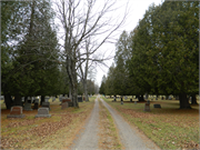
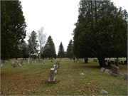
| Additional Information: | The Greenwood Cemetery is located between State Highway 35 and the BNSF railroad tracks about a half mile south of the Village of Superior. The rectangular-shaped cemetery features connected gravel roads throughout the cemetery, six heading east-west and three heading north-south. The central road features a metal “Greenwood Cemetery” sign along State Highway 35. A chain link fence is located along the southern, western, and northern boundaries of the cemetery. Vegetation includes deciduous and coniferous trees that appear to have been planted in rows and columns. There appear to be over 10,000 burials in the cemetery, arranged in rows and columns. The oldest burial in the cemetery appears to date to 1901 and the most recent is from 2011. The headstones consist of marble and granite tablets, granite slant markers, flush markers, obelisks, and crypts (2011). A circular-shaped Veteran Memorial Park is located in the southeast portion of the cemetery. This portion of the cemetery includes military tablets of World War I, World War II, Korea, and Vietnam veterans. A Grand Army of the Republic memorial and flagpole are centrally located in this portion of the cemetery. (2011) This property was previously surveyed in 1999. A 'site file' exists for this property. It contains additional information such as correspondence, newspaper clippings, or historical information. It is a public record and may be viewed in person at the State Historical Society, Division of Historic Preservation (1999). |
|---|---|
| Bibliographic References: | Phase I and II Architectural History Survey for the Northern Light Express Project, Anoka, Carlton, Hennepin, Isanti, Kanabex, Pine and St. Louis Counties, Minnesota, and Douglas County, Wisconsin: Volume 1. The 106 Group, May 2013. |
| Wisconsin Architecture and History Inventory, State Historic Preservation Office, Wisconsin Historical Society, Madison, Wisconsin |


