Roughly bounded by West Grange and Catalpa Street


| Historic Name: | Greendale Historic District |
|---|---|
| Reference Number: | 05000763 |
| Location (Address): | Roughly bounded by West Grange and Catalpa Street |
|---|---|
| County: | Milwaukee |
| City/Village: | Greendale |
| Township: |
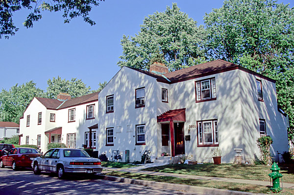
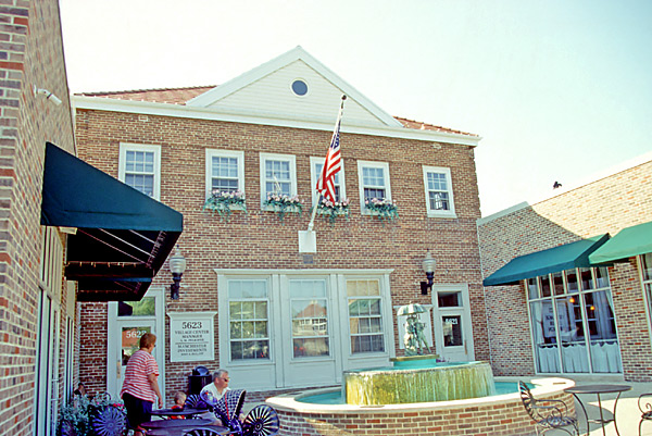
| Greendale Historic District Roughly bounded by West Grange Avenue and Catalpa Street, Greendale, Milwaukee County Architects: Harry Bentley and Walter Thomas Dates of construction: 1936-1938 Greendale, Wisconsin is one of three "greenbelt towns" built by the federal government during the Great Depression. The others were Greenbelt, Maryland and Greenhills, Ohio. The greenbelt towns program was an attempt by President Roosevelt's New Deal administration to intervene in the desperate U.S. housing market - depressed by unemployment, expanding urban slums and a shortage of adequate housing - and to illustrate the benefits of community planning as a remedy. The idea for the greenbelt towns was first pitched to President Roosevelt in 1935 by Undersecretary of Agriculture Rexford Guy Tugwell, who based his proposal for the design of the towns on principles pioneered by the Garden City movement in England. As formulated by Sir Ebenezer Howard, the Garden City was an ideal, self-contained community of predetermined area and population surrounded by a "greenbelt" of farms and parkland that would insulate the community from the troubles of the urban environment. The Garden City was intended to bring together the economic and cultural advantages of both city and country living, while at the same time discouraging suburban sprawl and industrial centralization. Tugwell's idea was "to go just outside centers of population, pick up cheap land, build a whole community, and entice people to it. Then go back into the cities and tear down whole slums and make parks of them." Out of 100 major industrial cities studied as possible candidates for an experimental greenbelt town, Milwaukee was chosen for its varied and stable manufacturing sector, inexpensive peripheral land and progressive political climate. Preliminary plans for Greendale, developed by a team led by Cleveland landscape architect Elbert Peets, were finished in March 1936. Construction began in April, and a model house opened in February 1937. Greendale housing units would be rented from the government at a rate that targeted families of "moderate" income ($1,000 to $2,000 per year), and applicants were screened by the government according to very subjective criteria. Greendale was incorporated as a village in November 1938. In 1953 Greendale's undeveloped land, as well as the municipal and commercial buildings, were purchased by the private Milwaukee Community Development Corporation. The original plan for Greendale employed several innovative planning concepts. Residential areas were laid out within three irregular superblocks, large blocks with housing clustered along narrow residential lanes. Parks and common greenspace flowed through and along the edges of each superblock. Paved walkways separated pedestrian from vehicular traffic. Houses were "turned around" so that the kitchen and utility room were on the street side and the living room was on the rear, or garden, side of the house. Today, Greendale's historic district reflects the influence of the Garden City model on American town planning. It demonstrates a uniquely American blending of informal, naturalistic residential areas and formal urban centers to provide a pedestrian- and family-oriented environment that encouraged its residents to form a cooperative community. The residential portions of the community are private homes. Please respect the rights and privacy of the residents. |
| Period of Significance: | 1936-1952 |
|---|---|
| Area of Significance: | Architecture |
| Area of Significance: | Community Planning And Development |
| Applicable Criteria: | Event |
| Applicable Criteria: | Architecture/Engineering |
| Historic Use: | Government: City Hall |
| Historic Use: | Education: School |
| Historic Use: | Domestic: Multiple Dwelling |
| Historic Use: | Domestic: Single Dwelling |
| Architectural Style: | Colonial Revival |
| Resource Type: | District |
| Architect: | Bentley, Harry |
| Architect: | Thomas, Walter |
| Historic Status: | Listed in the National Register |
|---|---|
| Historic Status: | Listed in the State Register |
| Historic Status: | National Historic Landmark Status Granted |
| National Register Listing Date: | 07/29/2005 |
| State Register Listing Date: | 04/15/2005 |
| Number of Contributing Buildings: | 586 |
|---|---|
| Number of Contributing Sites: | 1 |
| Number of Contributing Structures: | 3 |
| Number of Contributing Objects: | 1 |
| Number of Non-Contributing Buildings: | 16 |
| Number of Non-Contributing Sites: | 0 |
| Number of Non-Contributing Structures: | 2 |
| Number of Non-Contributing Objects: | 1 |
| National Register and State Register of Historic Places, State Historic Preservation Office, Wisconsin Historical Society, Madison, Wisconsin |