About Our Maps in Books
Digitally Reproduced Maps of Wisconsin and American History
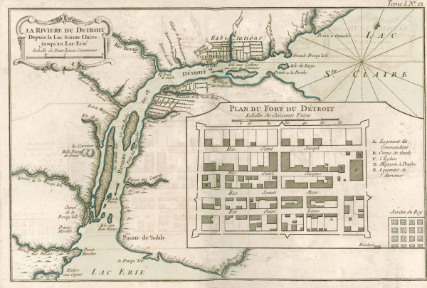
La Riviere du Detroit, 1764.
Historic map from the American Journeys website. View the original source document.
The Society has digitally reproduced hundreds of maps from rare books, manuscripts, magazines and journals that cover all aspects of Wisconsin and American history.
Maps in Books is compiled from books and magazines including Wisconsin County Histories, Wisconsin Historical Collections, Wisconsin Magazine of History and the American Journeys website, a digital library and learning center of eyewitness accounts of early American exploration and settlement.
How Maps in Books Are Organized
Online
Maps in Books can be browsed by clicking on a link below. Note: These maps generally do not display the same high level of detail as most of our online maps.
Browse digitized American Journeys maps
View 102 online maps ranging from 1492-1850 from the American Journeys website in the Society's collections.Browse digitized Wisconsin County Histories maps
View 39 online maps from 90 volumes of Wisconsin County Histories books in the Society's collections.Browse digitized Wisconsin Historical Collections maps
View 14 online maps ranging from 1856-1914, compiled from 20 volumes of the Wisconsin Historical Collections 1855-1915 in the Society's collections.Browse digitzied Wisconsin Magazine of History maps
View hundreds of maps ranging from 1917-present, compiled from more than 2,000 articles published in the Wisconsin Magazine of History now in the Society's collections.
Physical
The original paper maps are widely scattered throughout books and journals in the Society's Library. Only a few of these maps are located in the Archives' maps and atlases holdings.
Checking Out Materials
Most maps and atlases not circulate and must be used at the Society's Library or Archives. Also, some may be sent to any of our 13 Area Research Centers around the state for viewing.
Purchasing Copies
Photocopies of documents in the physical collections are available for a fee. High quality map reproductions suitable for framing may be available for purchase from the Wisconsin Historical Society. For more information about purchasing a reproduction or licensing for commercial use, email the Library Archives staff.
How to Cite
Bibliographic data will appear below each online document. Copy and paste the bibliographic data into your preferred citation manager.
Rights and Permissions
Digital maps on the Wisconsin Historical Society website may be printed or downloaded at no cost for nonprofit educational use by teachers and students, or for private use by individual researchers. Nothing may be reproduced in any format for commercial purposes without prior permission from the Wisconsin Historical Society.
Have Questions?
Contact our Library and Archives staff by email.