Atomic Age Evacuation Route Sign
Wisconsin Historical Museum Object – Feature Story

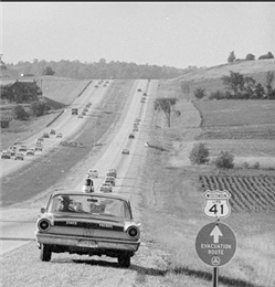
"Evacuation Route" sign on Highway 41 , 1961
An "Evacuation Route" sign on Highway 41 outside of Milwaukee, 1961. View the original source document: WHI 106377

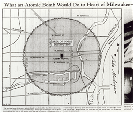
Hiroshima atomic bomb blast on Milwaukee, 1945
Map from the Milwaukee Journal showing how the Hiroshima atomic bomb blast would have obliterated the "whole heart of Milwaukee," August 8, 1945. Source: Wisconsin Historical Museum microfilm P3617

Hypothetical impact of a hydrogen bomb on Milwaukee, 1954
Map of Milwaukee showing in dark orange the area that must be completely evacuated if a hydrogen bomb threatened downtown Milwaukee with the area that authorities recommended be evacuated if time allowed shown in lighter orange. Source: An Evacuation Study of the Milwaukee Metropolitan Area for the Federal Civil Defense Administration, 1954

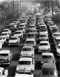
Congest traffic, 1957
Congested traffic leaving a World Series game at Milwaukee County Stadium in 1957 would have been similar to that expected during a mass evacuation from the city. View the original source document: WHI 8655
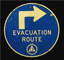
Evacuation Route road sign used to direct Milwaukee, Wisconsin residents out of town in the event of a potential nuclear bomb detonation, installed 1955-1957.
(Museum object #1996.121.1)
A mushroom cloud over Milwaukee! During the mid-1950s many Milwaukeeans feared that the Soviet Union saw their city as a desirable nuclear bomb target because of its industrial nature and significant population. To prepare for this potential catastrophe Milwaukee officials created an evacuation plan that would send city dwellers quickly and efficiently to Wisconsin's hinterlands where they would remain until the area was declared safe to return. This sign was one of many placed around Milwaukee to show evacuees the route they should take if an atomic blast was imminent.
After the Soviet Union detonated its first atomic bomb in 1949, Americans began to fear that an atomic war loomed over the horizon. After the Soviets tested their first hydrogen bomb in 1953, the fear only increased. How to survive an atomic attack became a major topic of discussion among federal and local officials across the United States. During President Truman's administration, the Federal Civil Defense Administration (FCDA) focused on public shelters, but President Eisenhower, inaugurated in 1953, believed this approach was fiscally irresponsible and asked the FCDA to turn its attention to evacuation instead.
Milwaukee, more than any other city in Wisconsin, felt it had an atomic bomb bulls-eye target drawn over it. Consequently, the city's government emphasized preparations to survive a nuclear attack. As early as 1951, the Milwaukee Civil Defense and Disaster Committee identified a need for an "Evacuation" division, believing that evacuation was "the most effective defense against atomic attack."
In 1954, the FCDA chose Milwaukee as a locale for an evacuation plan study "because of its target value, the cooperative attitude of its officials, and the previous interest in evacuation that had developed there." The plan assumed that Milwaukee would be a secondary target, giving it enough time to evacuate most of its citizens, and that any bomb sent to destroy the city would be 20 megatons in size (or 1000 times the size of the atomic bomb the United States dropped on Nagasaki, Japan in 1945).
The evacuation plan estimated that the area of total destruction would be eleven miles in diameter, or the whole of downtown Milwaukee. Severe damage would occur in the surrounding communities of St. Francis, Wauwatosa, and Fox Point; moderate damage in the towns of South Milwaukee, Watertown and Bayside; and light damage in northern Racine County, Waukesha, and Cedarburg. To be safe, citizens would have to evacuate beyond this outer ring of towns where "dispersal centers," mainly to the west and north of Milwaukee (Chicago was considered a primary target, so going south was not a viable option), would be set up to meet them. In ideal conditions the plan's authors estimated complete evacuation would take seven hours, and over fifteen in the worst conditions.
Local officials divided the city into wedge shapes with people evacuating to the outer ring of safety within those zones along feeder and radial routes. No cross traffic between wedges would be allowed, which meant that families probably would be separated. Evacuation planners realized that this approach would "not allow for the individual to serve the needs of himself and his family in contradiction to the basic plan." Education would be needed to let people know they could reunite at the dispersal centers, before being sent to "welfare centers" in Burlington, Oconomowoc, Slinger, and a few other outlying towns.
On June 15-16, 1955, Milwaukee participated in "Operation Alert," a National Civil Defense Test Exercise that simulated an atomic bomb evacuation for police and city officials. The public could listen along, but did not actively participate. The test warning signal went off at 10:00am on the June 15 and police were at their traffic control points within 20 minutes. The test supposed that a .2 megaton bomb hit Milwaukee at 1:04pm with ground zero at the intersection of North Second and West Clybourn Streets. The exercise continued until noon on June 16.
The Milwaukee City Civil Defense Committee, which submitted a report later in the month, concluded, among other things, that "escape route marking signs are absolutely essential to any successful movement." They urged the FCDA to stop delaying the selection of standard route markers, and noted that further indecision about the signs "will do increasing harm to the whole evacuation concept." Eventually, a decision was made and signs installed throughout the Milwaukee area.
The FCDA held Operation Alert tests annually around the United States between 1954 and 1961, but by 1957 had realized the futility of evacuation. As Milwaukee Mayor Frank P. Zeidler stated in a speech at a national security conference, "We have already encountered certain psychological difficulties with our people," who preferred to die from the bomb blast at home than from radioactive fallout during an evacuation attempt. Also, evacuation required expanded highways and roads, which turned out to be as expensive as public shelters. Finally, by this time the Soviets had developed intercontinental ballistic missiles that took only a half hour to arrive in the United States, leaving inadequate time for evacuation. As a result public and private shelters returned as the most viable option for surviving an atomic apocalypse and remained so through President Kennedy's administration.
[SOURCES: Wilbur Smith and Associates, "An Evacuation Study of the Milwaukee Metropolitan Area for the Federal Civil Defense Administration", November 1954; Milwaukee Civil Defense and Disaster Committee, "The Milwaukee Plan: Organization Manual", September 1951; "Milwaukee City Civil Defense Administration, A Report of Participation by the City of Milwaukee in the National Civil Defense Test Exercise of June 15-16, 1955"; "A Report on the Washington Conference of Mayors and Other Local Government Executives on National Security", December 2-3, 1954; Rose, Kenneth D. "One Nation Underground: The Fallout Shelter in American Culture" (NY: New York University Press, 2001); McEnaney, Laura. "Civil Defense Begins at Home: Militarization Meets Everyday Life in the 1950s" (Princeton, NJ: Princeton University Press, 2000).]
LAB
Learn More
Have Questions?
For more information or to purchase an image of one of the objects featured in Curators' Favorites, contact our staff by email below:
Posted on December 25, 2008

