Search: LIGHTHOUSES
Filter: Subject of water
Search: LIGHTHOUSES
Filter: Subject of water

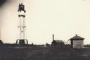
| Date: | |
|---|---|
| Description: | View toward the two lighthouses on either side of Kenosha Harbor. The lighthouse on the right has an elevated walkway to the entrance. Caption reads: "Ligh... |
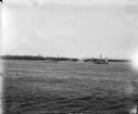
| Date: | 07 07 1898 |
|---|---|
| Description: | View across water of Sturgeon Bay. In the far distance are lighthouses, buildings, and barges along the shoreline. |

| Date: | 1902 |
|---|---|
| Description: | This map shows shoals near Waugoshance Point. Lighthouses are labeled. Depths are shown by soundings and tints. Relief is shown by hachures. Inset includes... |

| Date: | 1931 |
|---|---|
| Description: | This U.S. Geological Survey map of Wisconsin shows counties, cities and villages, lighthouses, Indian reservations, military reservations, and bird and gam... |

| Date: | 1946 |
|---|---|
| Description: | Map of Kewaunee County, Wisconsin, shows towns, cities and villages, roads and highways, railroads, schools, lighthouses, place names, town divisions, comm... |

| Date: | 1911 |
|---|---|
| Description: | This map of Duluth and Superior shows street car routes, railroads, ferries, some points of interest, and lighthouses. The bottom left of the map reads: "C... |

| Date: | 1848 |
|---|---|
| Description: | This map shows lighthouses on part of Lake Superior, Green Bay, Lake Michigan, Lake Huron, Lake St. Clair, Lake Erie, Lake Ontario, the St. Lawrence River,... |

| Date: | |
|---|---|
| Description: | Michigan Island Lighthouse, Apostle Islands, Lake Superior. |

| Date: | 1938 |
|---|---|
| Description: | This map shows roads, parks, golf courses, airports, beaches, docks and harbors, lighthouses, and buoys within Winnebago County and parts of Waushara, Calu... |

| Date: | 1848 |
|---|---|
| Description: | Wisconsin became the thirtieth state in 1848. Drawn that same year, this map shows township lines, roads, villages, mills, railroads, prairies, swamps, can... |

| Date: | 1896 |
|---|---|
| Description: | This 1896 map of Racine and Kenosha counties, Wisconsin, shows the township and range grid, towns, sections, cities, villages and post offices, roads, rail... |
| Date: | |
|---|---|
| Description: | Lighthouse and buildings on Devil's Island of the Apostle Islands. |
| Date: | 1950 |
|---|---|
| Description: | Lighthouse on Outer Island of the Apostle Islands. |
| Date: | 1947 |
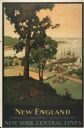
|---|---|
| Description: | An original lithograph promoting New York Central Lines railway and the area of New England, deemed "America's Historic Summerland" in the poster. Featurin... |

| Date: | 1912 |
|---|---|
| Description: | This map from the U.S. General Land Office shows railroads, counties, cities and villages, rivers, lakes, U.S. Land Offices, Indian reservations, military ... |
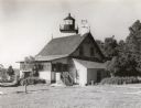
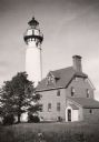
| Date: | 1960 |
|---|---|
| Description: | A view of the Eagle Harbor Lighthouse. |

| Date: | 1880 |
|---|---|
| Description: | Map of Wisconsin including the eastern portions on Minnesota, Iowa, northern Illinois, and the western most portion of Michigan’s Upper Peninsula, showing ... |

| Date: | 1916 |
|---|---|
| Description: | This Wisconsin Conservation Commission map from 1916 shows Peninsula State Park in the Town of Gibraltar, Door County, Wisconsin. Depicted are open and pla... |
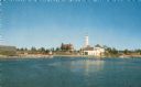
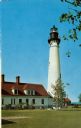
| Date: | |
|---|---|
| Description: | View of a U.S. lighthouse and Coast Guard station. |
If you didn't find the material you searched for, our Library Reference Staff can help.
Call our reference desk at 608-264-6535 or email us at: